 SAGE has been developing global databases of land use and land cover by combining satellite data and census data. This website provides access to our datasets of the distribution of the world’s natural vegetation, croplands, grazing lands, major crops, etc.
Available Data
- Population density: 1990, 1995
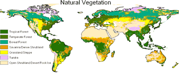
- Potential natural vegetation
- Cropland extent from 1700 to 1992
- Grazing land extent in 1992
- Built-up land extent in 1992
- 18 major crops extent in 1992
- Land suitability for cultivation
We provide data in two different formats: as maps (spatially explicit: gridded raster format) or in tabular format (by political/administrative units: countries, states, etc.). You can interpolate the raster data to match your desired spatial resolution (GCM spectral grids are also supported), or aggregate/disaggregate the administrative-level data to match your desired set of political units.
Select the Data Type
Finest Data Resolution is 0.5 degree in latitude by longitude.
Maximum disaggergation has 2605 first-level administration units such as states and provinces.
This project was funded by the Office of Biological and Environmental Research at the Department of Energy.