Results
| Country: | U.S.A.
| | Station: | WAMEGO, KS | | River: | KANSAS R | | Area: | 13674.39 | | Lat: | 39.19 | | Lon: | -96.3 | | Source: | USGS | | PointID: | 6887500 | | Area Units: | km2 | | Discharge Units: | m3/sec | | Starting Year: | 1982 | | Ending Year: | 1984 | | Total Years: | 3 | | Total Usable Years: | 2 | |
| |
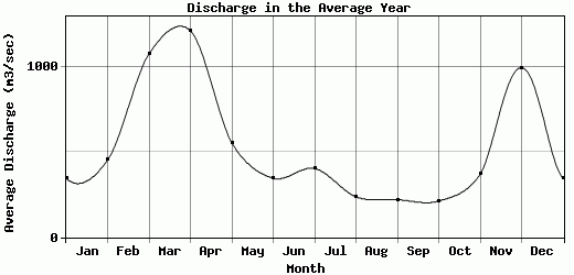
| Year | Jan | Feb | Mar | Apr | May | Jun | Jul | Aug | Sep | Oct | Nov | Dec | Avg Annual |
|---|
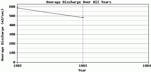
| 1982 | 277.23 | 520.02 | 1577.07 | 1039.52 | 373.32 | 333.12 | 376.78 | 277.93 | 200.08 | 186.17 | 432.94 | 1454.76 | 587.41 |
| 1983 | 415.33 | 386.01 | 573.46 | 1384.32 | 734.05 | 358.94 | 429.38 | 197.38 | 239.22 | 238.8 | 307.26 | 535.47 | 483.3 |
| 1984 | -9999 | -9999 | -9999 | -9999 | -9999 | -9999 | -9999 | -9999 | -9999 | -9999 | -9999 | -9999 | -9999 |
| |
|
|
|
|
|
|
|
|
|
|
|
|
|
| Avg | 346.28 | 453.02 | 1075.26 | 1211.92 | 553.68 | 346.03 | 403.08 | 237.66 | 219.65 | 212.49 | 370.1 | 995.12 | 535.36 |
| |
|
|
|
|
|
|
|
|
|
|
|
|
|
| Std Dev | 69.05 |
67.01 |
501.81 |
172.4 |
180.37 |
12.91 |
26.3 |
40.28 |
19.57 |
26.32 |
62.84 |
459.65 |
52.06 |
| |
|
|
|
|
|
|
|
|
|
|
|
|
|
| | Jan | Feb | Mar | Apr | May | Jun | Jul | Aug | Sep | Oct | Nov | Dec | Avg Annual |
Click here for this table in tab-delimited format.
Tab-delimited format will open in most table browsing software, i.e. Excel, etc.
View this station on the map.
Return to start.