Results
| Country: | Zambia
| | Station: | ManyingaRoad Bridge | | River: | Manyinga | | Area: | -9999 km2 | | Lat: | -13.14 | | Lon: | 24.2 | | Source: | RivDIS | | PointID: | 1457 | | Area Units: | km2 | | Discharge Units: | m3/sec | | Starting Year: | 1980 | | Ending Year: | 1984 | | Total Years: | 5 | | Total Usable Years: | 5 | |
| |
| Year | Jan | Feb | Mar | Apr | May | Jun | Jul | Aug | Sep | Oct | Nov | Dec | Avg Annual |
|---|
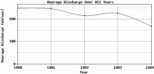
| 1980 | 356 | 399 | 457 | 450 | 282 | 196 | 170 | 144 | 124 | 94.7 | 105 | 210 | 248.98 |
| 1981 | 255 | 350 | 696 | 472 | 247 | 168 | 143 | 125 | 107 | 97.2 | 120 | 183 | 246.93 |
| 1982 | 230 | 334 | 416 | 282 | 194 | 154 | 155 | 157 | 120 | 122 | 152 | 278 | 216.17 |
| 1983 | 275 | 354 | 373 | 414 | 247 | 190 | 166 | 143 | 126 | 120 | 130 | 179 | 226.42 |
| 1984 | 253 | 265 | 299 | 241 | 150 | 127 | 119 | 106 | 89.8 | 84.1 | 107 | 180 | 168.41 |
| |
|
|
|
|
|
|
|
|
|
|
|
|
|
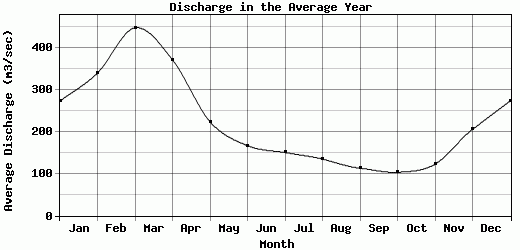
| Avg | 273.8 | 340.4 | 448.2 | 371.8 | 224 | 167 | 150.6 | 135 | 113.36 | 103.6 | 122.8 | 206 | 221.38 |
| |
|
|
|
|
|
|
|
|
|
|
|
|
|
| Std Dev | 43.5 |
43.44 |
134.49 |
92.85 |
46.47 |
25.06 |
18.38 |
17.72 |
13.51 |
14.89 |
17.2 |
37.77 |
29.23 |
| |
|
|
|
|
|
|
|
|
|
|
|
|
|
| | Jan | Feb | Mar | Apr | May | Jun | Jul | Aug | Sep | Oct | Nov | Dec | Avg Annual |
Click here for this table in tab-delimited format.
Tab-delimited format will open in most table browsing software, i.e. Excel, etc.
View this station on the map.
Return to start.