Results
| Country: | U.S.A.
| | Station: | PERMA, MT. | | River: | FLATHEAD RIVER | | Area: | 44053837.84 | | Lat: | 47.37 | | Lon: | -114.58 | | Source: | USGS | | PointID: | 12388700 | | Area Units: | km2 | | Discharge Units: | m3/sec | | Starting Year: | 1890 | | Ending Year: | 1892 | | Total Years: | 3 | | Total Usable Years: | 2 | |
| |
| Year | Jan | Feb | Mar | Apr | May | Jun | Jul | Aug | Sep | Oct | Nov | Dec | Avg Annual |
|---|
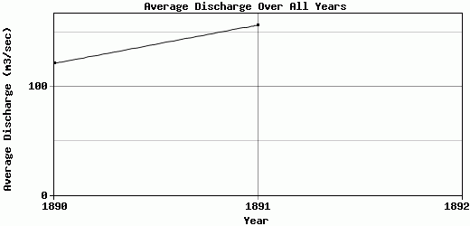
| 1890 | 84.95 | 84.95 | 84.95 | 131.96 | 296.9 | 285.58 | 142.15 | 62.84 | 63.29 | 65.1 | 81.18 | 75.7 | 121.63 |
| 1891 | 85.69 | 99.11 | 113.27 | 164.05 | 267.16 | 386.72 | 258.21 | 125.02 | 86.88 | 99.44 | 107.6 | 90.61 | 156.98 |
| 1892 | -9999 | -9999 | -9999 | -9999 | -9999 | -9999 | -9999 | -9999 | -9999 | -9999 | -9999 | -9999 | -9999 |
| |
|
|
|
|
|
|
|
|
|
|
|
|
|
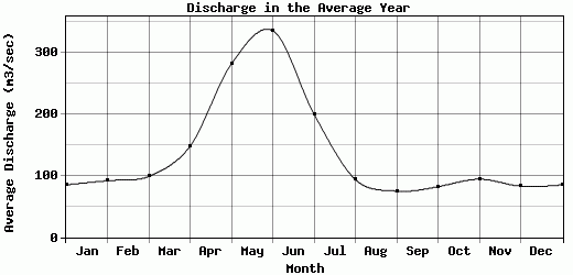
| Avg | 85.32 | 92.03 | 99.11 | 148.01 | 282.03 | 336.15 | 200.18 | 93.93 | 75.08 | 82.27 | 94.39 | 83.16 | 139.31 |
| |
|
|
|
|
|
|
|
|
|
|
|
|
|
| Std Dev | 0.37 |
7.08 |
14.16 |
16.05 |
14.87 |
50.57 |
58.03 |
31.09 |
11.8 |
17.17 |
13.21 |
7.46 |
17.68 |
| |
|
|
|
|
|
|
|
|
|
|
|
|
|
| | Jan | Feb | Mar | Apr | May | Jun | Jul | Aug | Sep | Oct | Nov | Dec | Avg Annual |
Click here for this table in tab-delimited format.
Tab-delimited format will open in most table browsing software, i.e. Excel, etc.
View this station on the map.
Return to start.