Results
| Country: | U.S.A.
| | Station: | Monroe,Louisiana | | River: | Ouachita | | Area: | 39622 km2 | | Lat: | 32.5 | | Lon: | -92.13 | | Source: | RivDIS | | PointID: | 381 | | Area Units: | km2 | | Discharge Units: | m3/sec | | Starting Year: | 1965 | | Ending Year: | 1975 | | Total Years: | 11 | | Total Usable Years: | 11 | |
| |
| Year | Jan | Feb | Mar | Apr | May | Jun | Jul | Aug | Sep | Oct | Nov | Dec | Avg Annual |
|---|
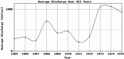
| 1965 | 354 | 630 | 923 | 846 | 120 | 111 | 81 | 99 | 196 | 67 | 44 | 45 | 293 |
| 1966 | 104 | 652 | 396 | 158 | 1260 | 710 | 68 | 182 | 158 | 105 | 69 | 87 | 329.08 |
| 1967 | 203 | 218 | 238 | 223 | 724 | 604 | 216 | 104 | 79 | 40 | 93 | 268 | 250.83 |
| 1968 | 825 | 877 | 644 | 1100 | 1240 | 1600 | 894 | 173 | 233 | 180 | 156 | 679 | 716.75 |
| 1969 | 598 | 1010 | 1150 | 1050 | 459 | 256 | 104 | 176 | 86 | 55 | 130 | 159 | 436.08 |
| 1970 | 738 | 578 | 1020 | 1070 | 1190 | 462 | 52 | 43 | 64 | 72 | 196 | 185 | 472.5 |
| 1971 | 300 | 264 | 402 | 137 | 300 | 80 | 108 | 352 | 56 | 36 | 45 | 400 | 206.67 |
| 1972 | 739 | 414 | 366 | 253 | 173 | 45 | 74 | 51 | 119 | 99 | 672 | 1167 | 347.67 |
| 1973 | 1400 | 1450 | 1580 | 1810 | 2130 | 1230 | 627 | 153 | 259 | 289 | 511 | 1240 | 1056.58 |
| 1974 | 1620 | 1660 | 1300 | 905 | 1020 | 1340 | 1300 | 201 | 896 | 698 | 698 | 1190 | 1069 |
| 1975 | 1350 | 1630 | 1630 | 1670 | 1760 | 1460 | 862 | 293 | 172 | 71 | 93.5 | 155 | 928.88 |
| |
|
|
|
|
|
|
|
|
|
|
|
|
|
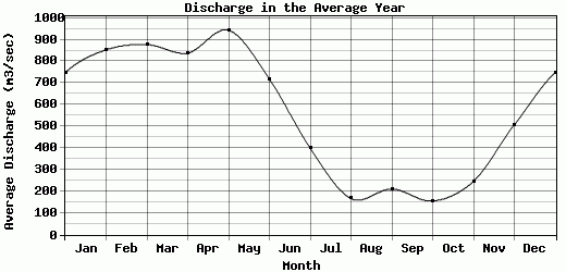
| Avg | 748.27 | 853 | 877.18 | 838.36 | 943.27 | 718 | 398.73 | 166.09 | 210.73 | 155.64 | 246.14 | 506.82 | 555.19 |
| |
|
|
|
|
|
|
|
|
|
|
|
|
|
| Std Dev | 490.29 |
499.57 |
478.44 |
562.72 |
625.08 |
563.91 |
422.66 |
90.06 |
226.38 |
185.41 |
241.07 |
454.88 |
313.22 |
| |
|
|
|
|
|
|
|
|
|
|
|
|
|
| | Jan | Feb | Mar | Apr | May | Jun | Jul | Aug | Sep | Oct | Nov | Dec | Avg Annual |
Click here for this table in tab-delimited format.
Tab-delimited format will open in most table browsing software, i.e. Excel, etc.
View this station on the map.
Return to start.