Results
| Country: | U.S.A.
| | Station: | FT. SUMNER, N.M. | | River: | PECOS RIVER BL. YESO ARROYO NR. | | Area: | 18128.93 | | Lat: | 34.22 | | Lon: | -104.22 | | Source: | USGS | | PointID: | 8385620 | | Area Units: | km2 | | Discharge Units: | m3/sec | | Starting Year: | 1986 | | Ending Year: | 1991 | | Total Years: | 6 | | Total Usable Years: | 5 | |
| |
| Year | Jan | Feb | Mar | Apr | May | Jun | Jul | Aug | Sep | Oct | Nov | Dec | Avg Annual |
|---|
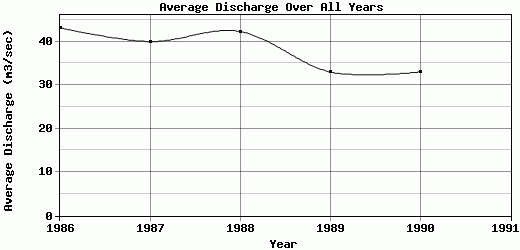
| 1986 | 37.63 | 50.97 | 56.63 | 58.68 | 46.83 | 42.13 | 34.14 | 34.25 | 40.98 | 40.32 | 37.42 | 37.88 | 43.16 |
| 1987 | 38.05 | 43.65 | 60.95 | 59.42 | 45.74 | 37.08 | 31.14 | 30.35 | 37 | 30.54 | 32.67 | 33.37 | 40 |
| 1988 | 32.16 | 40.5 | 81.11 | 47.78 | 77.94 | 35.72 | 36.15 | 28.82 | 28.95 | 31.14 | 31.69 | 36.01 | 42.33 |
| 1989 | 34.61 | 38.91 | 46.79 | 44.58 | 32.79 | 26.08 | 25.83 | 24.01 | 28.5 | 30.17 | 33.04 | 31.18 | 33.04 |
| 1990 | 35.55 | 34.72 | 39.11 | 37.84 | 38.99 | 35.76 | 24.99 | 27.44 | 25.75 | 30.61 | 31.64 | 33.83 | 33.02 |
| 1991 | -9999 | -9999 | -9999 | -9999 | -9999 | -9999 | -9999 | -9999 | -9999 | -9999 | -9999 | -9999 | -9999 |
| |
|
|
|
|
|
|
|
|
|
|
|
|
|
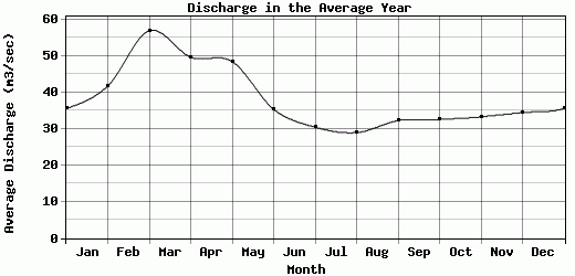
| Avg | 35.6 | 41.75 | 56.92 | 49.66 | 48.46 | 35.35 | 30.45 | 28.97 | 32.24 | 32.56 | 33.29 | 34.45 | 38.31 |
| |
|
|
|
|
|
|
|
|
|
|
|
|
|
| Std Dev | 2.14 |
5.43 |
14.29 |
8.31 |
15.58 |
5.2 |
4.42 |
3.37 |
5.76 |
3.89 |
2.13 |
2.3 |
4.43 |
| |
|
|
|
|
|
|
|
|
|
|
|
|
|
| | Jan | Feb | Mar | Apr | May | Jun | Jul | Aug | Sep | Oct | Nov | Dec | Avg Annual |
Click here for this table in tab-delimited format.
Tab-delimited format will open in most table browsing software, i.e. Excel, etc.
View this station on the map.
Return to start.