Results
| Country: | Ecuador
| | Station: | Lechugal | | River: | Zapotal | | Area: | 2300 km2 | | Lat: | -1.4 | | Lon: | -79.4 | | Source: | RivDIS | | PointID: | 467 | | Area Units: | km2 | | Discharge Units: | m3/sec | | Starting Year: | 1966 | | Ending Year: | 1972 | | Total Years: | 7 | | Total Usable Years: | 7 | |
| |
| Year | Jan | Feb | Mar | Apr | May | Jun | Jul | Aug | Sep | Oct | Nov | Dec | Avg Annual |
|---|
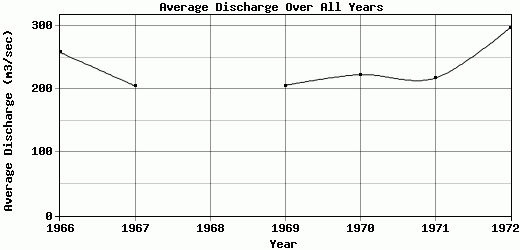
| 1966 | 75 | 459 | 785 | 768 | 370 | 269 | 114 | 62 | 50 | 39 | 67 | 41 | 258.25 |
| 1967 | 64 | 389 | 684 | 585 | 202 | 215 | 134 | 62 | 41 | 32 | 30 | 24 | 205.17 |
| 1968 | 37 | 246 | 362 | 312 | 224 | 125 | 72 | 48 | 35 | 36 | 35 | -9999 | -9999 |
| 1969 | 192 | 226 | 465 | 595 | 327 | 284 | 130 | 57.5 | 44 | 31.5 | 31 | 88 | 205.92 |
| 1970 | 309 | 524 | 404 | 570 | 430 | 169 | 77 | 49 | 36.5 | 32 | 30 | 46 | 223.04 |
| 1971 | 196 | 529 | 798 | 528 | 164 | 95 | 61 | 42 | 45 | 40 | 39 | 71.5 | 217.38 |
| 1972 | 276 | 504 | 627 | 551 | 386 | 446 | 215 | 95 | 73 | 90 | 64 | 237 | 297 |
| |
|
|
|
|
|
|
|
|
|
|
|
|
|
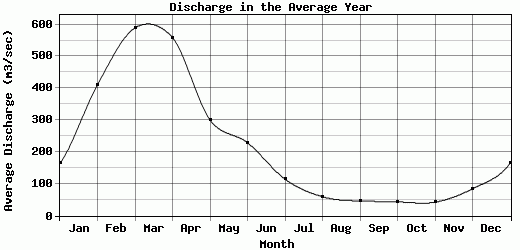
| Avg | 164.14 | 411 | 589.29 | 558.43 | 300.43 | 229 | 114.71 | 59.36 | 46.36 | 42.93 | 42.29 | 84.58 | 234.46 |
| |
|
|
|
|
|
|
|
|
|
|
|
|
|
| Std Dev | 99.59 |
119.27 |
166.35 |
124.1 |
95.47 |
109.73 |
48.98 |
16.15 |
11.86 |
19.48 |
15 |
71.27 |
33.1 |
| |
|
|
|
|
|
|
|
|
|
|
|
|
|
| | Jan | Feb | Mar | Apr | May | Jun | Jul | Aug | Sep | Oct | Nov | Dec | Avg Annual |
Click here for this table in tab-delimited format.
Tab-delimited format will open in most table browsing software, i.e. Excel, etc.
View this station on the map.
Return to start.