Results
| Country: | U.S.A.
| | Station: | ANSONVILLE N C | | River: | PEE DEE R | | Area: | 16393.73 | | Lat: | 35.08 | | Lon: | -79.99 | | Source: | USGS | | PointID: | 2127500 | | Area Units: | km2 | | Discharge Units: | m3/sec | | Starting Year: | 1938 | | Ending Year: | 1942 | | Total Years: | 5 | | Total Usable Years: | 4 | |
| |
| Year | Jan | Feb | Mar | Apr | May | Jun | Jul | Aug | Sep | Oct | Nov | Dec | Avg Annual |
|---|
| 1938 | -9999 | -9999 | 170.05 | 183.2 | 93.95 | 137.21 | 229.66 | 151.64 | 114.67 | 86.91 | 103.81 | 138.72 | -9999 |
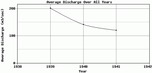
| 1939 | 175.23 | 591.95 | 416.34 | 166.39 | 137.84 | 126.65 | 156.27 | 287.84 | 127.28 | 100.03 | 73.15 | 62.15 | 201.76 |
| 1940 | 118.14 | 191.42 | 138.75 | 148.26 | 103.48 | 92.39 | 99.29 | 287.9 | 143.69 | 101.94 | 136.63 | 137.46 | 141.61 |
| 1941 | 137.33 | 118.56 | 157.05 | 183.79 | 103.84 | 109.57 | 251.62 | 89.46 | 78.3 | 88.35 | 53.07 | 75.2 | 120.51 |
| 1942 | 83.3 | 187.75 | 369.14 | 152.21 | 209.04 | 207.88 | 136.19 | 128.28 | 206.34 | -9999 | -9999 | -9999 | -9999 |
| |
|
|
|
|
|
|
|
|
|
|
|
|
|
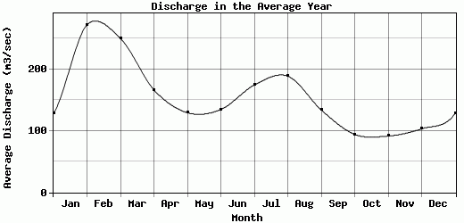
| Avg | 128.5 | 272.42 | 250.27 | 166.77 | 129.63 | 134.74 | 174.61 | 189.02 | 134.06 | 94.31 | 91.67 | 103.38 | 154.63 |
| |
|
|
|
|
|
|
|
|
|
|
|
|
|
| Std Dev | 33.21 |
186.75 |
117.7 |
14.93 |
42.42 |
39.62 |
57.35 |
83.12 |
42.07 |
6.73 |
31.63 |
35.02 |
34.42 |
| |
|
|
|
|
|
|
|
|
|
|
|
|
|
| | Jan | Feb | Mar | Apr | May | Jun | Jul | Aug | Sep | Oct | Nov | Dec | Avg Annual |
Click here for this table in tab-delimited format.
Tab-delimited format will open in most table browsing software, i.e. Excel, etc.
View this station on the map.
Return to start.