Results
| Country: | U.S.A.
| | Station: | NEAR CLANTON AL | | River: | COOSA RIVER (AT OLD LOCK 12) | | Area: | 23748.89 | | Lat: | 32.96 | | Lon: | -86.52 | | Source: | USGS | | PointID: | 2408000 | | Area Units: | km2 | | Discharge Units: | m3/sec | | Starting Year: | 1912 | | Ending Year: | 1914 | | Total Years: | 3 | | Total Usable Years: | 2 | |
| |
| Year | Jan | Feb | Mar | Apr | May | Jun | Jul | Aug | Sep | Oct | Nov | Dec | Avg Annual |
|---|
| 1912 | -9999 | -9999 | -9999 | -9999 | -9999 | -9999 | -9999 | -9999 | -9999 | 209.13 | 133.9 | 312.04 | -9999 |
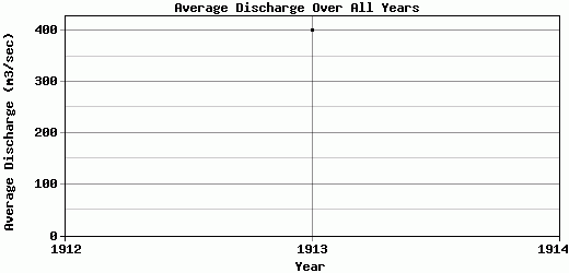
| 1913 | 690.02 | 939.92 | 1320.94 | 471.03 | 271.06 | 231.63 | 173.19 | 170.12 | 114.81 | 162.78 | 92.09 | 166.98 | 400.38 |
| 1914 | 189.09 | 354.86 | 239.49 | 650.91 | 179.78 | 97.79 | 142.1 | 162.73 | 100.06 | -9999 | -9999 | -9999 | -9999 |
| |
|
|
|
|
|
|
|
|
|
|
|
|
|
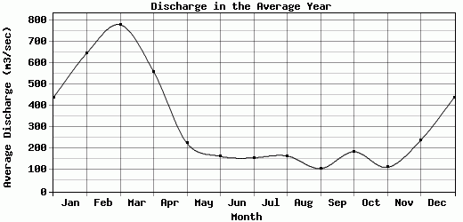
| Avg | 439.56 | 647.39 | 780.22 | 560.97 | 225.42 | 164.71 | 157.64 | 166.43 | 107.44 | 185.96 | 113 | 239.51 | 400.38 |
| |
|
|
|
|
|
|
|
|
|
|
|
|
|
| Std Dev | 250.47 |
292.53 |
540.73 |
89.94 |
45.64 |
66.92 |
15.55 |
3.7 |
7.38 |
23.18 |
20.91 |
72.53 |
0 |
| |
|
|
|
|
|
|
|
|
|
|
|
|
|
| | Jan | Feb | Mar | Apr | May | Jun | Jul | Aug | Sep | Oct | Nov | Dec | Avg Annual |
Click here for this table in tab-delimited format.
Tab-delimited format will open in most table browsing software, i.e. Excel, etc.
View this station on the map.
Return to start.