Results
| Country: | U.S.A.
| | Station: | COY AL | | River: | ALABAMA RIVER | | Area: | 54749.35 | | Lat: | 31.92 | | Lon: | -87.49 | | Source: | USGS | | PointID: | 2428000 | | Area Units: | km2 | | Discharge Units: | m3/sec | | Starting Year: | 1928 | | Ending Year: | 1934 | | Total Years: | 7 | | Total Usable Years: | 6 | |
| |
| Year | Jan | Feb | Mar | Apr | May | Jun | Jul | Aug | Sep | Oct | Nov | Dec | Avg Annual |
|---|
| 1928 | -9999 | -9999 | -9999 | -9999 | -9999 | -9999 | -9999 | -9999 | -9999 | 390.77 | 376.43 | 441.93 | -9999 |
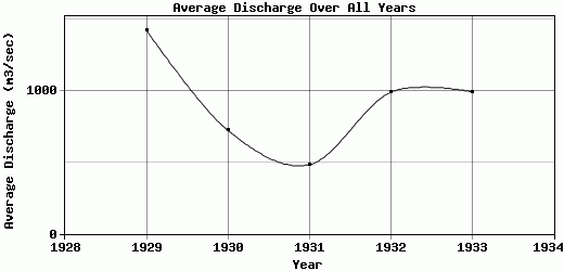
| 1929 | 602.06 | 1208.33 | 5630.52 | 1598.87 | 1970.13 | 652.23 | 526.33 | 401.83 | 370.91 | 423.59 | 2500.49 | 1216.63 | 1425.16 |
| 1930 | 970.82 | 1465.1 | 1676.27 | 843.47 | 571.64 | 337 | 324.74 | 364.15 | 431.99 | 396.71 | 832.9 | 477.64 | 724.37 |
| 1931 | 709.75 | 619.74 | 674.86 | 931.35 | 509.34 | 332.29 | 259.48 | 279.43 | 225.8 | 203.12 | 181.55 | 871.38 | 483.17 |
| 1932 | 1416.03 | 2249.83 | 970.27 | 1081.33 | 772.23 | 466.85 | 667.28 | 457.82 | 397.2 | 464.19 | 611.08 | 2324.19 | 989.86 |
| 1933 | 2814.34 | 2013.95 | 2102.31 | 1670.99 | 712.58 | 427.49 | 472.53 | 365.38 | 358.4 | 337.28 | 329.14 | 329.24 | 994.47 |
| 1934 | 518.45 | 410.23 | 1685.87 | 588.24 | 455.36 | 597.87 | 390.77 | 580.22 | 395.78 | -9999 | -9999 | -9999 | -9999 |
| |
|
|
|
|
|
|
|
|
|
|
|
|
|
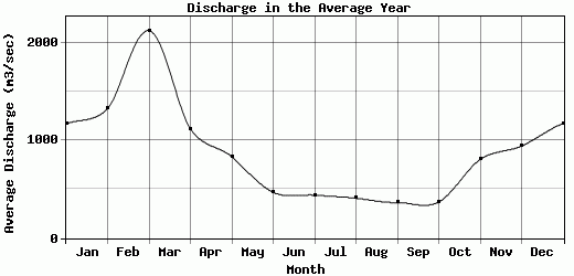
| Avg | 1171.91 | 1327.86 | 2123.35 | 1119.04 | 831.88 | 468.95 | 440.19 | 408.14 | 363.35 | 369.28 | 805.27 | 943.5 | 923.41 |
| |
|
|
|
|
|
|
|
|
|
|
|
|
|
| Std Dev | 791.93 |
670.49 |
1639.09 |
393.54 |
520.73 |
121.12 |
134.45 |
93.5 |
65.71 |
83.47 |
786.54 |
687.02 |
314.53 |
| |
|
|
|
|
|
|
|
|
|
|
|
|
|
| | Jan | Feb | Mar | Apr | May | Jun | Jul | Aug | Sep | Oct | Nov | Dec | Avg Annual |
Click here for this table in tab-delimited format.
Tab-delimited format will open in most table browsing software, i.e. Excel, etc.
View this station on the map.
Return to start.