Results
| Country: | U.S.A.
| | Station: | BREEDENTON TENN | | River: | TENNESSEE R | | Area: | 15590878.46 | | Lat: | 35.54 | | Lon: | -84.8 | | Source: | USGS | | PointID: | 3544000 | | Area Units: | km2 | | Discharge Units: | m3/sec | | Starting Year: | 1934 | | Ending Year: | 1940 | | Total Years: | 7 | | Total Usable Years: | 6 | |
| |
| Year | Jan | Feb | Mar | Apr | May | Jun | Jul | Aug | Sep | Oct | Nov | Dec | Avg Annual |
|---|
| 1934 | -9999 | 343.82 | 2130.35 | 965.61 | 422.65 | 460.43 | 400.02 | 518.2 | 259.24 | 389.38 | 383.01 | 525.42 | -9999 |
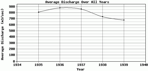
| 1935 | 1196.99 | 1022.45 | 2121.22 | 1813.33 | 931.99 | 503.67 | 423.11 | 364.5 | 264.2 | 162.82 | 532.48 | 378.93 | 809.64 |
| 1936 | 2010.47 | 1624.32 | 1750.72 | 1925.27 | 423.81 | 269.26 | 335.99 | 311.88 | 332.31 | 518.58 | 343.13 | 714.32 | 880.01 |
| 1937 | 2465.95 | 1950.43 | 985.98 | 637.32 | 652.94 | 433.53 | 339.07 | 438.73 | 431.93 | 638.69 | 656.67 | 689.91 | 860.1 |
| 1938 | 854.08 | 779.32 | 1169.22 | 981.66 | 731.49 | 820.82 | 864.31 | 812.79 | 413.43 | 362.55 | 474.52 | 551.18 | 734.61 |
| 1939 | 684.54 | 2336.76 | 1541.91 | 836.48 | 478.56 | 350.82 | 370.98 | 335.38 | 342.73 | 304.68 | 294.82 | 266.6 | 678.69 |
| 1940 | 208.78 | 504.41 | -9999 | -9999 | -9999 | -9999 | -9999 | -9999 | -9999 | -9999 | -9999 | -9999 | -9999 |
| |
|
|
|
|
|
|
|
|
|
|
|
|
|
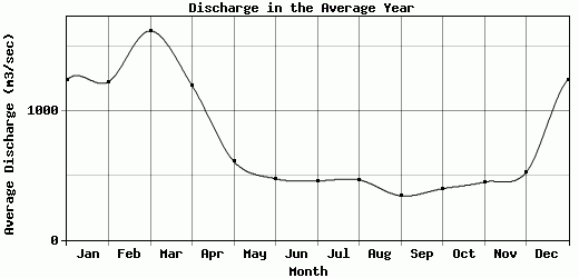
| Avg | 1236.8 | 1223.07 | 1616.57 | 1193.28 | 606.91 | 473.09 | 455.58 | 463.58 | 340.64 | 396.12 | 447.44 | 521.06 | 792.61 |
| |
|
|
|
|
|
|
|
|
|
|
|
|
|
| Std Dev | 776.66 |
702.76 |
435.89 |
492.15 |
185.86 |
173.24 |
185.4 |
170.69 |
66.05 |
151.55 |
122.52 |
159.03 |
75.93 |
| |
|
|
|
|
|
|
|
|
|
|
|
|
|
| | Jan | Feb | Mar | Apr | May | Jun | Jul | Aug | Sep | Oct | Nov | Dec | Avg Annual |
Click here for this table in tab-delimited format.
Tab-delimited format will open in most table browsing software, i.e. Excel, etc.
View this station on the map.
Return to start.