Results
| Country: | U.S.A.
| | Station: | OSLO, MN | | River: | RED RIVER OF THE NORTH AT | | Area: | 23361207.83 | | Lat: | 48.19 | | Lon: | -97.14 | | Source: | USGS | | PointID: | 5083500 | | Area Units: | km2 | | Discharge Units: | m3/sec | | Starting Year: | 1973 | | Ending Year: | 1976 | | Total Years: | 4 | | Total Usable Years: | 3 | |
| |
| Year | Jan | Feb | Mar | Apr | May | Jun | Jul | Aug | Sep | Oct | Nov | Dec | Avg Annual |
|---|
| 1973 | -9999 | -9999 | -9999 | -9999 | -9999 | -9999 | -9999 | -9999 | -9999 | 106.69 | 69.19 | 55.08 | -9999 |
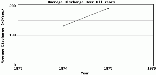
| 1974 | 49.14 | 46.82 | 57.27 | 489.7 | 394.61 | 178.21 | 84.95 | 77.64 | 51.35 | 55.05 | 57.21 | 35.12 | 131.42 |
| 1975 | 36.78 | 40.51 | 49.05 | 498.62 | 448.14 | 166.71 | 724.55 | 87.42 | 63.52 | 66.12 | 66.55 | 50.21 | 191.52 |
| 1976 | 48.33 | 47.71 | 93.61 | 274.82 | 74.32 | 43.77 | 31.85 | 28.13 | 20.3 | -9999 | -9999 | -9999 | -9999 |
| |
|
|
|
|
|
|
|
|
|
|
|
|
|
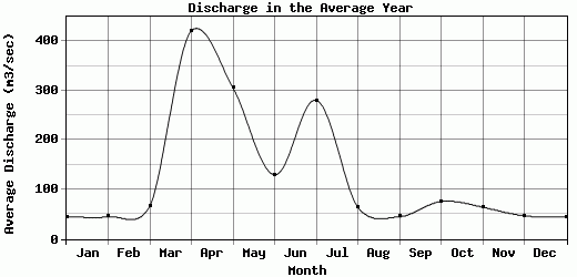
| Avg | 44.75 | 45.01 | 66.64 | 421.05 | 305.69 | 129.56 | 280.45 | 64.4 | 45.06 | 75.95 | 64.32 | 46.8 | 161.47 |
| |
|
|
|
|
|
|
|
|
|
|
|
|
|
| Std Dev | 5.65 |
3.21 |
19.36 |
103.46 |
165.06 |
60.85 |
314.77 |
25.95 |
18.2 |
22.2 |
5.14 |
8.5 |
30.05 |
| |
|
|
|
|
|
|
|
|
|
|
|
|
|
| | Jan | Feb | Mar | Apr | May | Jun | Jul | Aug | Sep | Oct | Nov | Dec | Avg Annual |
Click here for this table in tab-delimited format.
Tab-delimited format will open in most table browsing software, i.e. Excel, etc.
View this station on the map.
Return to start.