Results
| Country: | U.S.A.
| | Station: | HENRY | | River: | ILLINOIS RIVER | | Area: | 35074.29 | | Lat: | 41.11 | | Lon: | -89.35 | | Source: | USGS | | PointID: | 5558900 | | Area Units: | km2 | | Discharge Units: | m3/sec | | Starting Year: | 1981 | | Ending Year: | 1984 | | Total Years: | 4 | | Total Usable Years: | 3 | |
| |
| Year | Jan | Feb | Mar | Apr | May | Jun | Jul | Aug | Sep | Oct | Nov | Dec | Avg Annual |
|---|
| 1981 | -9999 | -9999 | -9999 | -9999 | -9999 | -9999 | -9999 | -9999 | -9999 | 276.47 | 219.06 | 242.89 | -9999 |
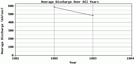
| 1982 | 277.23 | 520.02 | 1577.07 | 1039.52 | 373.32 | 333.12 | 376.78 | 277.93 | 200.08 | 186.17 | 432.94 | 1454.76 | 587.41 |
| 1983 | 415.33 | 386.01 | 573.46 | 1384.32 | 734.05 | 358.94 | 429.38 | 197.38 | 239.22 | 238.8 | 307.26 | 535.47 | 483.3 |
| 1984 | 322.45 | 731.92 | 796.07 | 714.63 | 694.68 | 578.14 | 249.7 | 200.37 | 208.68 | -9999 | -9999 | -9999 | -9999 |
| |
|
|
|
|
|
|
|
|
|
|
|
|
|
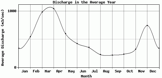
| Avg | 338.34 | 545.98 | 982.2 | 1046.16 | 600.68 | 423.4 | 351.95 | 225.23 | 215.99 | 233.81 | 319.75 | 744.37 | 535.36 |
| |
|
|
|
|
|
|
|
|
|
|
|
|
|
| Std Dev | 57.49 |
142.41 |
430.34 |
273.44 |
161.57 |
109.92 |
75.43 |
37.29 |
16.79 |
37.03 |
87.76 |
516.33 |
52.06 |
| |
|
|
|
|
|
|
|
|
|
|
|
|
|
| | Jan | Feb | Mar | Apr | May | Jun | Jul | Aug | Sep | Oct | Nov | Dec | Avg Annual |
Click here for this table in tab-delimited format.
Tab-delimited format will open in most table browsing software, i.e. Excel, etc.
View this station on the map.
Return to start.