Results
| Country: | U.S.A.
| | Station: | MEREDOSIA, IL | | River: | ILLINOIS RIVER | | Area: | 67411.11 | | Lat: | 39.82 | | Lon: | -90.57 | | Source: | USGS | | PointID: | 5585500 | | Area Units: | km2 | | Discharge Units: | m3/sec | | Starting Year: | 1988 | | Ending Year: | 1992 | | Total Years: | 5 | | Total Usable Years: | 1 | |
| |
| Year | Jan | Feb | Mar | Apr | May | Jun | Jul | Aug | Sep | Oct | Nov | Dec | Avg Annual |
|---|
| 1988 | -9999 | -9999 | -9999 | -9999 | -9999 | -9999 | -9999 | -9999 | -9999 | 0 | 0 | -9999 | -9999 |
| 1989 | -9999 | -9999 | -9999 | -9999 | -9999 | -9999 | -9999 | 0.06 | 0.2 | -9999 | -9999 | -9999 | -9999 |
| 1990 | -9999 | -9999 | -9999 | -9999 | -9999 | -9999 | -9999 | -9999 | -9999 | -9999 | -9999 | -9999 | -9999 |
| 1991 | -9999 | -9999 | -9999 | -9999 | -9999 | -9999 | -9999 | -9999 | -9999 | 367.85 | 555.45 | 731.13 | -9999 |
| 1992 | 405.54 | 498.67 | 623.61 | 550.48 | 387.39 | 258.63 | 494.09 | 488.71 | 382.83 | -9999 | -9999 | -9999 | -9999 |
| |
|
|
|
|
|
|
|
|
|
|
|
|
|
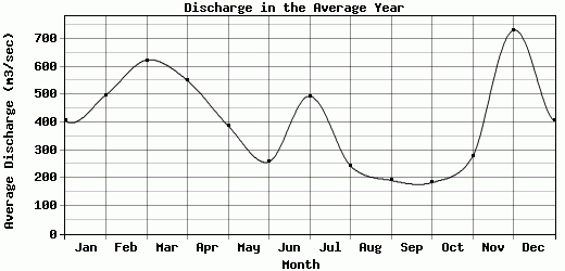
| Avg | 405.54 | 498.67 | 623.61 | 550.48 | 387.39 | 258.63 | 494.09 | 244.39 | 191.52 | 183.93 | 277.73 | 731.13 | -9999 |
| |
|
|
|
|
|
|
|
|
|
|
|
|
|
| Std Dev | 0 |
0 |
0 |
0 |
0 |
0 |
0 |
244.33 |
191.32 |
183.93 |
277.73 |
0 |
0 |
| |
|
|
|
|
|
|
|
|
|
|
|
|
|
| | Jan | Feb | Mar | Apr | May | Jun | Jul | Aug | Sep | Oct | Nov | Dec | Avg Annual |
Click here for this table in tab-delimited format.
Tab-delimited format will open in most table browsing software, i.e. Excel, etc.
View this station on the map.
Return to start.