Results
| Country: | U.S.A.
| | Station: | CUSTER, MT. | | River: | YELLOWSTONE RIVER | | Area: | 26079772.28 | | Lat: | 46.14 | | Lon: | -107.55 | | Source: | USGS | | PointID: | 6218000 | | Area Units: | km2 | | Discharge Units: | m3/sec | | Starting Year: | 1906 | | Ending Year: | 1907 | | Total Years: | 2 | | Total Usable Years: | 1 | |
| |
| Year | Jan | Feb | Mar | Apr | May | Jun | Jul | Aug | Sep | Oct | Nov | Dec | Avg Annual |
|---|
| 1906 | -9999 | -9999 | -9999 | -9999 | 464.46 | 569.17 | 412.24 | 199.98 | 127.94 | 88.93 | 78.37 | 79.65 | -9999 |
| 1907 | 42.48 | -9999 | 88.81 | 113.19 | 277.5 | 787.12 | 973.47 | 373.85 | 187.83 | 139.67 | 103.43 | 86.09 | -9999 |
| |
|
|
|
|
|
|
|
|
|
|
|
|
|
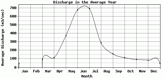
| Avg | 42.48 | 0 | 88.81 | 113.19 | 370.98 | 678.15 | 692.86 | 286.92 | 157.89 | 114.3 | 90.9 | 82.87 | -9999 |
| |
|
|
|
|
|
|
|
|
|
|
|
|
|
| Std Dev | 0 |
0 |
0 |
0 |
93.48 |
108.98 |
280.62 |
86.94 |
29.95 |
25.37 |
12.53 |
3.22 |
0 |
| |
|
|
|
|
|
|
|
|
|
|
|
|
|
| | Jan | Feb | Mar | Apr | May | Jun | Jul | Aug | Sep | Oct | Nov | Dec | Avg Annual |
Click here for this table in tab-delimited format.
Tab-delimited format will open in most table browsing software, i.e. Excel, etc.
View this station on the map.
Return to start.