Results
| Country: | U.S.A.
| | Station: | DECATUR, NE | | River: | MISSOURI RIVER | | Area: | 818805.87 | | Lat: | 42 | | Lon: | -96.24 | | Source: | USGS | | PointID: | 6601200 | | Area Units: | km2 | | Discharge Units: | m3/sec | | Starting Year: | 1987 | | Ending Year: | 1993 | | Total Years: | 7 | | Total Usable Years: | 6 | |
| |
| Year | Jan | Feb | Mar | Apr | May | Jun | Jul | Aug | Sep | Oct | Nov | Dec | Avg Annual |
|---|
| 1987 | -9999 | -9999 | -9999 | -9999 | -9999 | -9999 | -9999 | -9999 | -9999 | 920.21 | 930.87 | 577.3 | -9999 |
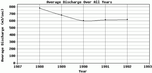
| 1988 | 526.51 | 572.59 | 746.29 | 904.26 | 921.49 | 928.14 | 903.68 | 919.48 | 1014.88 | 958.03 | 650.06 | 377.71 | 785.26 |
| 1989 | 398.45 | 472.19 | 464.03 | 878.49 | 923.86 | 901.99 | 893.45 | 905.6 | 820.06 | 827.13 | 331.78 | 407.03 | 685.34 |
| 1990 | 350.03 | 384.71 | 341.05 | 725.76 | 786.94 | 799.86 | 796.07 | 774.24 | 876.88 | 777.35 | 296.39 | 341.83 | 604.26 |
| 1991 | 437.63 | 345.74 | 327.82 | 691.12 | 739.99 | 799.58 | 783.74 | 822.2 | 909.16 | 828.59 | 321.68 | 386.21 | 616.12 |
| 1992 | 400.37 | 380.91 | 497.56 | 719.16 | 768.94 | 812.23 | 898.56 | 765.29 | 764.94 | 686.64 | 332.63 | 422.2 | 620.79 |
| 1993 | 411.14 | 432.74 | 655.13 | 887.27 | 954.92 | 1063.59 | 1457.87 | 727.75 | 757.48 | -9999 | -9999 | -9999 | -9999 |
| |
|
|
|
|
|
|
|
|
|
|
|
|
|
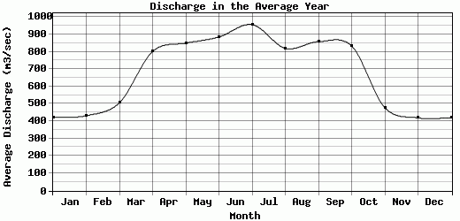
| Avg | 420.69 | 431.48 | 505.31 | 801.01 | 849.36 | 884.23 | 955.56 | 819.09 | 857.23 | 832.99 | 477.23 | 418.71 | 662.35 |
| |
|
|
|
|
|
|
|
|
|
|
|
|
|
| Std Dev | 53.97 |
74.91 |
153.17 |
89.95 |
85.85 |
94.76 |
229.88 |
71.67 |
89.24 |
89.27 |
236.16 |
75.22 |
67.64 |
| |
|
|
|
|
|
|
|
|
|
|
|
|
|
| | Jan | Feb | Mar | Apr | May | Jun | Jul | Aug | Sep | Oct | Nov | Dec | Avg Annual |
Click here for this table in tab-delimited format.
Tab-delimited format will open in most table browsing software, i.e. Excel, etc.
View this station on the map.
Return to start.