Results
| Country: | U.S.A.
| | Station: | PFEIFER, KS | | River: | SMOKY HILL R | | Area: | 15624.54 | | Lat: | 38.71 | | Lon: | -99.15 | | Source: | USGS | | PointID: | 6863000 | | Area Units: | km2 | | Discharge Units: | m3/sec | | Starting Year: | 1929 | | Ending Year: | 1932 | | Total Years: | 4 | | Total Usable Years: | 3 | |
| |
| Year | Jan | Feb | Mar | Apr | May | Jun | Jul | Aug | Sep | Oct | Nov | Dec | Avg Annual |
|---|
| 1929 | -9999 | -9999 | 0.87 | 0.69 | 7.93 | 0.91 | 2.91 | 0.4 | 1.05 | 0.94 | 0.76 | 0.51 | -9999 |
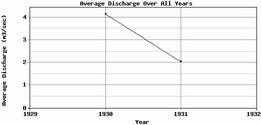
| 1930 | 0.25 | 0.58 | 0.42 | 0.35 | 1.83 | 12.21 | 2.21 | 2.64 | 2.39 | 17.71 | 6.52 | 2.66 | 4.15 |
| 1931 | 1.59 | 1.29 | 1.46 | 6.8 | 5.16 | 3.88 | 2.24 | 0.79 | 0.21 | 0.28 | 0.34 | 0.49 | 2.04 |
| 1932 | 0.21 | 0.5 | 0.7 | 0.55 | 0.59 | 5.18 | -9999 | -9999 | -9999 | -9999 | -9999 | -9999 | -9999 |
| |
|
|
|
|
|
|
|
|
|
|
|
|
|
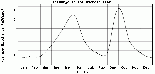
| Avg | 0.68 | 0.79 | 0.86 | 2.1 | 3.88 | 5.55 | 2.45 | 1.28 | 1.22 | 6.31 | 2.54 | 1.22 | 3.1 |
| |
|
|
|
|
|
|
|
|
|
|
|
|
|
| Std Dev | 0.64 |
0.36 |
0.38 |
2.72 |
2.88 |
4.15 |
0.32 |
0.98 |
0.9 |
8.07 |
2.82 |
1.02 |
1.06 |
| |
|
|
|
|
|
|
|
|
|
|
|
|
|
| | Jan | Feb | Mar | Apr | May | Jun | Jul | Aug | Sep | Oct | Nov | Dec | Avg Annual |
Click here for this table in tab-delimited format.
Tab-delimited format will open in most table browsing software, i.e. Excel, etc.
View this station on the map.
Return to start.