Results
| Country: | U.S.A.
| | Station: | DENISON DAM NEAR DENISON, TX | | River: | RED RIVER | | Area: | 102868.70 | | Lat: | 33.82 | | Lon: | -96.56 | | Source: | USGS | | PointID: | 7331600 | | Area Units: | km2 | | Discharge Units: | m3/sec | | Starting Year: | 1987 | | Ending Year: | 1989 | | Total Years: | 3 | | Total Usable Years: | 2 | |
| |
| Year | Jan | Feb | Mar | Apr | May | Jun | Jul | Aug | Sep | Oct | Nov | Dec | Avg Annual |
|---|
| 1987 | -9999 | -9999 | -9999 | -9999 | -9999 | -9999 | -9999 | -9999 | -9999 | 97.41 | 86.28 | 137.02 | -9999 |
| 1988 | 370.31 | 202.09 | 306.29 | 334.58 | 123.15 | 57.11 | 56.5 | 52.16 | 15.31 | 63.66 | 70.72 | 43.13 | 141.25 |
| 1989 | 51.18 | 87.15 | 140.85 | 99.49 | 170.59 | 733.84 | 546.68 | 140.54 | 199.28 | -9999 | -9999 | -9999 | -9999 |
| |
|
|
|
|
|
|
|
|
|
|
|
|
|
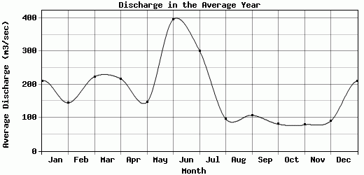
| Avg | 210.75 | 144.62 | 223.57 | 217.04 | 146.87 | 395.48 | 301.59 | 96.35 | 107.3 | 80.54 | 78.5 | 90.08 | 141.25 |
| |
|
|
|
|
|
|
|
|
|
|
|
|
|
| Std Dev | 159.57 |
57.47 |
82.72 |
117.55 |
23.72 |
338.37 |
245.09 |
44.19 |
91.99 |
16.88 |
7.78 |
46.95 |
0 |
| |
|
|
|
|
|
|
|
|
|
|
|
|
|
| | Jan | Feb | Mar | Apr | May | Jun | Jul | Aug | Sep | Oct | Nov | Dec | Avg Annual |
Click here for this table in tab-delimited format.
Tab-delimited format will open in most table browsing software, i.e. Excel, etc.
View this station on the map.
Return to start.