Results
| Country: | U.S.A.
| | Station: | AT SPOKANE | | River: | SPOKANE R. BLW. NINE MILE DAM | | Area: | 13467.20 | | Lat: | 47.77 | | Lon: | -117.54 | | Source: | USGS | | PointID: | 12426000 | | Area Units: | km2 | | Discharge Units: | m3/sec | | Starting Year: | 1948 | | Ending Year: | 1950 | | Total Years: | 3 | | Total Usable Years: | 2 | |
| |
| Year | Jan | Feb | Mar | Apr | May | Jun | Jul | Aug | Sep | Oct | Nov | Dec | Avg Annual |
|---|
| 1948 | -9999 | -9999 | 227.39 | 465.42 | 906.51 | 694.24 | 109.24 | 78.79 | 51.61 | 71.22 | 71.55 | 115.74 | -9999 |
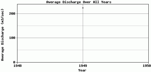
| 1949 | 102.43 | 152.73 | 367.57 | 579.55 | 808.13 | 251.84 | 68.49 | 46.11 | 35.86 | 51.36 | 100.84 | 127.45 | 224.36 |
| 1950 | 154.04 | 251 | 542.32 | 585.03 | 710.12 | 685.27 | 234.78 | 67.27 | 44.84 | -9999 | -9999 | -9999 | -9999 |
| |
|
|
|
|
|
|
|
|
|
|
|
|
|
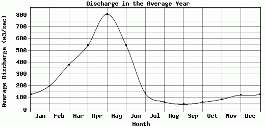
| Avg | 128.24 | 201.87 | 379.09 | 543.33 | 808.25 | 543.78 | 137.5 | 64.06 | 44.1 | 61.29 | 86.2 | 121.6 | 224.36 |
| |
|
|
|
|
|
|
|
|
|
|
|
|
|
| Std Dev | 25.81 |
49.14 |
128.83 |
55.14 |
80.18 |
206.47 |
70.77 |
13.53 |
6.45 |
9.93 |
14.65 |
5.86 |
0 |
| |
|
|
|
|
|
|
|
|
|
|
|
|
|
| | Jan | Feb | Mar | Apr | May | Jun | Jul | Aug | Sep | Oct | Nov | Dec | Avg Annual |
Click here for this table in tab-delimited format.
Tab-delimited format will open in most table browsing software, i.e. Excel, etc.
View this station on the map.
Return to start.