Results
| Country: | U.S.A.
| | Station: | MOUTH, NEAR YUMA, AZ. | | River: | GILA RIVER | | Area: | 39029507.16 | | Lat: | 32.71 | | Lon: | -114.55 | | Source: | USGS | | PointID: | 9520700 | | Area Units: | km2 | | Discharge Units: | m3/sec | | Starting Year: | 1990 | | Ending Year: | 1993 | | Total Years: | 4 | | Total Usable Years: | 3 | |
| |
| Year | Jan | Feb | Mar | Apr | May | Jun | Jul | Aug | Sep | Oct | Nov | Dec | Avg Annual |
|---|
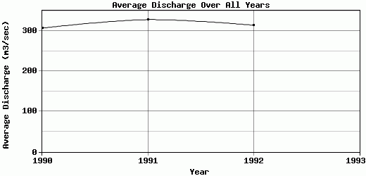
| 1990 | 310.31 | 300.08 | 289.51 | 275.54 | 292.15 | 361.82 | 367.71 | 443.32 | 340.56 | 209.78 | 232.22 | 263.7 | 307.22 |
| 1991 | 308.52 | 300.01 | 269.19 | 258.72 | 345.54 | 380.39 | 436.28 | 410.41 | 378.08 | 254.35 | 281.97 | 316.13 | 328.3 |
| 1992 | 356.72 | 308.44 | 268.47 | 268.89 | 274.2 | 320.35 | 394.89 | 392.69 | 335.03 | 252.54 | 284.94 | 316.05 | 314.43 |
| 1993 | -9999 | -9999 | -9999 | -9999 | -9999 | -9999 | -9999 | -9999 | -9999 | -9999 | -9999 | -9999 | -9999 |
| |
|
|
|
|
|
|
|
|
|
|
|
|
|
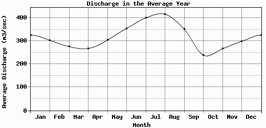
| Avg | 325.18 | 302.84 | 275.72 | 267.72 | 303.96 | 354.19 | 399.63 | 415.47 | 351.22 | 238.89 | 266.38 | 298.63 | 316.65 |
| |
|
|
|
|
|
|
|
|
|
|
|
|
|
| Std Dev | 22.31 |
3.96 |
9.75 |
6.92 |
30.3 |
25.1 |
28.19 |
20.98 |
19.12 |
20.6 |
24.18 |
24.7 |
8.75 |
| |
|
|
|
|
|
|
|
|
|
|
|
|
|
| | Jan | Feb | Mar | Apr | May | Jun | Jul | Aug | Sep | Oct | Nov | Dec | Avg Annual |
Click here for this table in tab-delimited format.
Tab-delimited format will open in most table browsing software, i.e. Excel, etc.
View this station on the map.
Return to start.