Results
| Country: | U.S.A.
| | Station: | CrookedCreek, Alaska | | River: | Kuskokwin | | Area: | 80549 km2 | | Lat: | 61.86 | | Lon: | -158.11 | | Source: | RivDIS | | PointID: | 340 | | Area Units: | km2 | | Discharge Units: | m3/sec | | Starting Year: | 1965 | | Ending Year: | 1984 | | Total Years: | 20 | | Total Usable Years: | 20 | |
| |
| Year | Jan | Feb | Mar | Apr | May | Jun | Jul | Aug | Sep | Oct | Nov | Dec | Avg Annual |
|---|
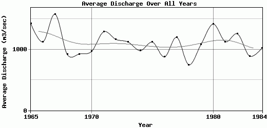
| 1965 | 340 | 328 | 323 | 334 | 1645 | 2918 | 2088 | 2901 | 3170 | 2120 | 594 | 324 | 1423.75 |
| 1966 | 240 | 200 | 170 | 270 | 1854 | 2651 | 2012 | 2090 | 1607 | 1360 | 620 | 420 | 1124.5 |
| 1967 | 400 | 400 | 540 | 1160 | 3687 | 2863 | 2723 | 3820 | 1736 | 860 | 423 | 325 | 1578.08 |
| 1968 | 294 | 280 | 280 | 298 | 2579 | 1870 | 1690 | 1400 | 890 | 717 | 412 | 311 | 918.42 |
| 1969 | 275 | 252 | 233 | 472 | 2060 | 1500 | 1530 | 1980 | 996 | 992 | 487 | 332 | 925.75 |
| 1970 | 288 | 280 | 280 | 290 | 1880 | 1730 | 1690 | 1880 | 1600 | 900 | 467 | 333 | 968.17 |
| 1971 | 288 | 280 | 266 | 315 | 3550 | 2250 | 2080 | 3030 | 1320 | 1170 | 565 | 372 | 1290.5 |
| 1972 | 316 | 280 | 249 | 281 | 3500 | 994 | 2140 | 1800 | 1850 | 1310 | 751 | 515 | 1165.5 |
| 1973 | 401 | 337 | 300 | 458 | 2820 | 2060 | 1600 | 1890 | 1440 | 1100 | 646 | 417 | 1122.42 |
| 1974 | 328 | 296 | 278 | 432 | 2540 | 1340 | 1310 | 1350 | 1500 | 1190 | 763 | 460 | 982.25 |
| 1975 | 339 | 284 | 259 | 264 | 2100 | 2260 | 2130 | 1600 | 2110 | 1230 | 532 | 336 | 1120.33 |
| 1976 | 292 | 280 | 268 | 265 | 2590 | 1740 | 1420 | 1280 | 855 | 726 | 479 | 337 | 877.67 |
| 1977 | 308 | 295 | 271 | 275 | 1840 | 3230 | 1700 | 1690 | 2150 | 1480 | 674 | 470 | 1198.58 |
| 1978 | 383 | 329 | 294 | 281 | 852 | 1160 | 1660 | 1530 | 1130 | 634 | 388 | 336 | 748.08 |
| 1979 | 308 | 308 | 285 | 425 | 2600 | 2090 | 2090 | 1900 | 1170 | 947 | 453 | 420 | 1083 |
| 1980 | 353 | 340 | 294 | 726 | 3314 | 2601 | 3382 | 2689 | 1725 | 885 | 360 | 334 | 1416.92 |
| 1981 | 311 | 288 | 288 | 549 | 2739 | 1473 | 2175 | 2372 | 1415 | 851 | 606 | 457 | 1127 |
| 1982 | 372 | 322 | 311 | 291 | 1936 | 2473 | 2151 | 2230 | 2390 | 1458 | 622 | 495 | 1254.25 |
| 1983 | 454 | 410 | 350 | 335 | 1519 | 1552 | 1312 | 1667 | 1353 | 748 | 548 | 452 | 891.67 |
| 1984 | 401 | 368 | 357 | 417 | 2695 | 1778 | 1453 | 1890 | 1295 | 760 | 505 | 341 | 1021.67 |
| |
|
|
|
|
|
|
|
|
|
|
|
|
|
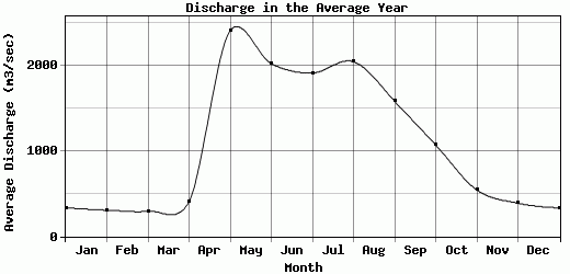
| Avg | 334.55 | 307.85 | 294.8 | 406.9 | 2415 | 2026.65 | 1916.8 | 2049.45 | 1585.1 | 1071.9 | 544.75 | 389.35 | 1111.93 |
| |
|
|
|
|
|
|
|
|
|
|
|
|
|
| Std Dev | 52.03 |
47.63 |
68.51 |
207.77 |
727.03 |
605.19 |
488.38 |
624.02 |
542.03 |
348.06 |
111.89 |
65.09 |
203.1 |
| |
|
|
|
|
|
|
|
|
|
|
|
|
|
| | Jan | Feb | Mar | Apr | May | Jun | Jul | Aug | Sep | Oct | Nov | Dec | Avg Annual |
Click here for this table in tab-delimited format.
Tab-delimited format will open in most table browsing software, i.e. Excel, etc.
View this station on the map.
Return to start.