Results
| Country: | Zambia
| | Station: | Masase | | River: | Lusiwasi | | Area: | 995 km2 | | Lat: | -13.22 | | Lon: | 31.03 | | Source: | RivDIS | | PointID: | 1537 | | Area Units: | km2 | | Discharge Units: | m3/sec | | Starting Year: | 1980 | | Ending Year: | 1984 | | Total Years: | 5 | | Total Usable Years: | 5 | |
| |
| Year | Jan | Feb | Mar | Apr | May | Jun | Jul | Aug | Sep | Oct | Nov | Dec | Avg Annual |
|---|
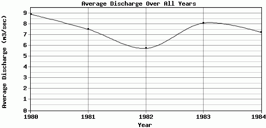
| 1980 | 7.19 | 10.9 | 21.7 | 19.4 | 10.8 | 8.01 | 6.71 | 5.27 | 4.22 | 4.25 | 4.08 | 4.39 | 8.91 |
| 1981 | 12.1 | 13.9 | 15.5 | 10.5 | 7.42 | 5.3 | 4.39 | 3.4 | 3.68 | 4.93 | 4.33 | 4.84 | 7.52 |
| 1982 | 9.03 | 12.4 | 6.77 | 5.41 | 4.3 | 2.95 | 3.06 | 3.12 | 3.43 | 3.71 | 4.47 | 10.4 | 5.75 |
| 1983 | 8.92 | 18.9 | 19.4 | 10 | 6.88 | 5.1 | 4.39 | 3.71 | 3.77 | 3.62 | 5.43 | 7.02 | 8.09 |
| 1984 | 11.4 | 17 | 13.9 | 9.01 | 5.66 | 3.17 | 3.77 | 3.46 | 3.46 | 3.68 | 3.82 | 8.52 | 7.24 |
| |
|
|
|
|
|
|
|
|
|
|
|
|
|
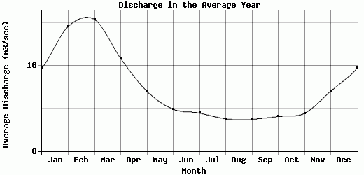
| Avg | 9.73 | 14.62 | 15.45 | 10.86 | 7.01 | 4.91 | 4.46 | 3.79 | 3.71 | 4.04 | 4.43 | 7.03 | 7.5 |
| |
|
|
|
|
|
|
|
|
|
|
|
|
|
| Std Dev | 1.79 |
2.94 |
5.15 |
4.62 |
2.18 |
1.83 |
1.23 |
0.76 |
0.28 |
0.5 |
0.55 |
2.25 |
1.05 |
| |
|
|
|
|
|
|
|
|
|
|
|
|
|
| | Jan | Feb | Mar | Apr | May | Jun | Jul | Aug | Sep | Oct | Nov | Dec | Avg Annual |
Click here for this table in tab-delimited format.
Tab-delimited format will open in most table browsing software, i.e. Excel, etc.
View this station on the map.
Return to start.