Results
| Country: | Canada
| | Station: | FortProvidence | | River: | Mackenzie | | Area: | 970000 km2 | | Lat: | 61.26 | | Lon: | -117.53 | | Source: | RivDIS | | PointID: | 276 | | Area Units: | km2 | | Discharge Units: | m3/sec | | Starting Year: | 1966 | | Ending Year: | 1975 | | Total Years: | 10 | | Total Usable Years: | 7 | |
| |
| Year | Jan | Feb | Mar | Apr | May | Jun | Jul | Aug | Sep | Oct | Nov | Dec | Avg Annual |
|---|
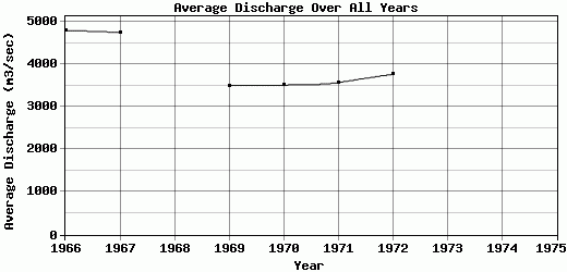
| 1966 | 2710 | 2670 | 2560 | 2490 | 4190 | 7450 | 7730 | 7390 | 7160 | 6600 | 3740 | 3000 | 4807.5 |
| 1967 | 2830 | 2420 | 1970 | 2000 | 4050 | 6800 | 8480 | 7820 | 7080 | 6570 | 4790 | 2280 | 4757.5 |
| 1968 | -9999 | -9999 | -9999 | -9999 | -9999 | -9999 | -9999 | -9999 | -9999 | -9999 | -9999 | -9999 | -9999 |
| 1969 | 1280 | 1190 | 1270 | 1220 | 4840 | 6120 | 5870 | 5160 | 5010 | 4610 | 3280 | 2180 | 3502.5 |
| 1970 | 1610 | 1420 | 1360 | 1550 | 4380 | 5830 | 5770 | 5390 | 4800 | 4310 | 3420 | 2330 | 3514.17 |
| 1971 | 1680 | 1490 | 1400 | 1440 | 5070 | 5690 | 5550 | 5440 | 5100 | 4700 | 2920 | 2470 | 3579.17 |
| 1972 | 2050 | 1790 | 1630 | 1630 | 3910 | 6030 | 6510 | 6170 | 5690 | 4760 | 2890 | 2210 | 3772.5 |
| 1973 | -9999 | -9999 | -9999 | -9999 | -9999 | 6960 | 6960 | 6680 | 6630 | 6140 | 527 | 419 | -9999 |
| 1974 | -9999 | -9999 | -9999 | -9999 | -9999 | 7730 | 7844 | 7504 | 7051 | 6258 | -9999 | -9999 | -9999 |
| 1975 | -9999 | -9999 | -9999 | -9999 | -9999 | 7500 | 6970 | 6290 | 5780 | 5510 | -9999 | -9999 | -9999 |
| |
|
|
|
|
|
|
|
|
|
|
|
|
|
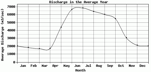
| Avg | 2026.67 | 1830 | 1698.33 | 1721.67 | 4406.67 | 6678.89 | 6853.78 | 6427.11 | 6033.44 | 5495.33 | 3081 | 2127 | 3988.89 |
| |
|
|
|
|
|
|
|
|
|
|
|
|
|
| Std Dev | 572.15 |
539.85 |
448.68 |
415.67 |
418.2 |
737.81 |
964.83 |
932.82 |
905.42 |
865.05 |
1200.88 |
743.67 |
568.26 |
| |
|
|
|
|
|
|
|
|
|
|
|
|
|
| | Jan | Feb | Mar | Apr | May | Jun | Jul | Aug | Sep | Oct | Nov | Dec | Avg Annual |
Click here for this table in tab-delimited format.
Tab-delimited format will open in most table browsing software, i.e. Excel, etc.
View this station on the map.
Return to start.