Results
| Country: | India
| | Station: | Kaimundi | | River: | Mahanadi | | Area: | 132090 km2 | | Lat: | 20.42 | | Lon: | 83.67 | | Source: | RivDIS | | PointID: | 860 | | Area Units: | km2 | | Discharge Units: | m3/sec | | Starting Year: | 1965 | | Ending Year: | 1970 | | Total Years: | 6 | | Total Usable Years: | 6 | |
| |
| Year | Jan | Feb | Mar | Apr | May | Jun | Jul | Aug | Sep | Oct | Nov | Dec | Avg Annual |
|---|
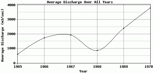
| 1965 | 230 | 261 | 311 | 345 | 249 | 271 | 1467 | 1362 | 1615 | 540 | 303 | 270 | 602 |
| 1966 | 426 | 425 | 466 | 481 | 377 | 1045 | 4884 | 7497 | 1911 | 1126 | 1110 | 899 | 1720.58 |
| 1967 | 556 | 534 | 664 | 673 | 520 | 718 | 3855 | 4820 | 6040 | 2070 | 1421 | 1316 | 1932.25 |
| 1968 | 137 | 140 | 122 | 144 | 127 | 289 | 2279 | 3447 | 1189 | 2179 | 212 | 51 | 859.67 |
| 1969 | 1115 | 1998 | 1182 | 1195 | 818 | 588 | 3590 | 10570 | 2525 | 2082 | 1649 | 1403 | 2392.92 |
| 1970 | 2090 | 2090 | 1862 | 1857 | 1658 | 1367 | 10500 | 10415 | 7771 | 3192 | 1479 | 1231 | 3792.67 |
| |
|
|
|
|
|
|
|
|
|
|
|
|
|
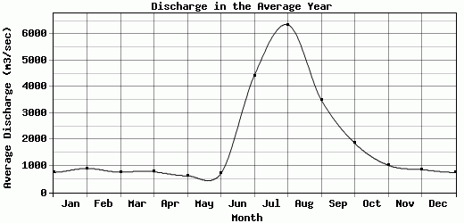
| Avg | 759 | 908 | 767.83 | 782.5 | 624.83 | 713 | 4429.17 | 6351.83 | 3508.5 | 1864.83 | 1029 | 861.67 | 1883.35 |
| |
|
|
|
|
|
|
|
|
|
|
|
|
|
| Std Dev | 672.94 |
813.1 |
591.1 |
581.19 |
510.92 |
393.43 |
2929.55 |
3447.14 |
2485.36 |
841.66 |
568.87 |
523.53 |
1050.7 |
| |
|
|
|
|
|
|
|
|
|
|
|
|
|
| | Jan | Feb | Mar | Apr | May | Jun | Jul | Aug | Sep | Oct | Nov | Dec | Avg Annual |
Click here for this table in tab-delimited format.
Tab-delimited format will open in most table browsing software, i.e. Excel, etc.
View this station on the map.
Return to start.