Results
| Country: | Colombia
| | Station: | Tagachi | | River: | Ateato | | Area: | 9432 km2 | | Lat: | 6.21 | | Lon: | -76.71 | | Source: | RivDIS | | PointID: | 1148 | | Area Units: | km2 | | Discharge Units: | m3/sec | | Starting Year: | 1976 | | Ending Year: | 1979 | | Total Years: | 4 | | Total Usable Years: | 4 | |
| |
| Year | Jan | Feb | Mar | Apr | May | Jun | Jul | Aug | Sep | Oct | Nov | Dec | Avg Annual |
|---|
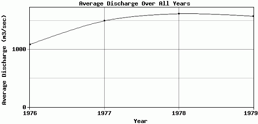
| 1976 | 1627 | 1258 | 865 | 854 | 1177 | 1436 | 963 | 1017 | 761 | 1055 | 1249 | 788 | 1087.5 |
| 1977 | 742 | 1200 | 875 | 1248 | 2051 | 1574 | 1742 | 1865 | 1499 | 2175 | 1585 | 1427 | 1498.58 |
| 1978 | 993 | 948 | 813 | 2107 | 2103 | 2184 | 1560 | 1477 | 1613 | 2051 | 1753 | 1879 | 1623.42 |
| 1979 | 967 | 1107 | 1179 | 1567 | 1652 | 1855 | 1622 | 1526 | 1838 | 2133 | 1786 | 1738 | 1580.83 |
| |
|
|
|
|
|
|
|
|
|
|
|
|
|
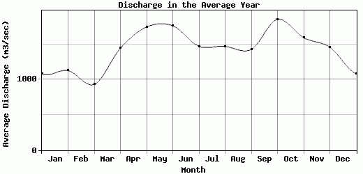
| Avg | 1082.25 | 1128.25 | 933 | 1444 | 1745.75 | 1762.25 | 1471.75 | 1471.25 | 1427.75 | 1853.5 | 1593.25 | 1458 | 1447.58 |
| |
|
|
|
|
|
|
|
|
|
|
|
|
|
| Std Dev | 329.31 |
117.18 |
143.97 |
458.59 |
371.84 |
286.51 |
300.93 |
301.83 |
403.81 |
463.17 |
212.87 |
419.97 |
212.68 |
| |
|
|
|
|
|
|
|
|
|
|
|
|
|
| | Jan | Feb | Mar | Apr | May | Jun | Jul | Aug | Sep | Oct | Nov | Dec | Avg Annual |
Click here for this table in tab-delimited format.
Tab-delimited format will open in most table browsing software, i.e. Excel, etc.
View this station on the map.
Return to start.