Results
| Country: | U.S.A.
| | Station: | PRESCOTT, WI | | River: | MISSISSIPPI RIVER | | Area: | 116025.12 | | Lat: | 44.74 | | Lon: | -92.8 | | Source: | USGS | | PointID: | 5344500 | | Area Units: | km2 | | Discharge Units: | m3/sec | | Starting Year: | 1976 | | Ending Year: | 1987 | | Total Years: | 12 | | Total Usable Years: | 11 | |
| |
| Year | Jan | Feb | Mar | Apr | May | Jun | Jul | Aug | Sep | Oct | Nov | Dec | Avg Annual |
|---|
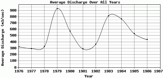
| 1976 | 283.69 | 454.78 | 921.03 | 714.61 | 237.17 | 303.05 | 376.62 | 62.64 | 90.13 | 92.54 | 151.02 | 209.34 | 324.72 |
| 1977 | 313.11 | 403.37 | 721.35 | 944.66 | 558.23 | 69.79 | 68.75 | 51.72 | 72.84 | 57.17 | 110.15 | 182.09 | 296.1 |
| 1978 | 293.46 | 600.32 | 467.96 | 304.15 | 892.9 | 339.82 | 85.53 | 71.3 | 102.01 | 41.64 | 171.49 | 568.35 | 328.24 |
| 1979 | 1082.99 | 1386.93 | 1400.96 | 1571.78 | 1931.77 | 1611.14 | 899.94 | 222.85 | 142.91 | 106.64 | 269.1 | 504.13 | 927.59 |
| 1980 | 694.04 | 997.05 | 778.17 | 1377.81 | 1323.04 | 777.38 | 63.01 | 39.88 | 64.44 | 188.96 | 220.63 | 313.83 | 569.85 |
| 1981 | 96.75 | 261.75 | 379.14 | 275.86 | 437.97 | 1008.09 | 464.14 | 125.4 | 68.59 | 122.06 | 122.82 | 119.42 | 290.17 |
| 1982 | 173.58 | 580.7 | 508.43 | 511.56 | 416.63 | 264.38 | 165.29 | 113.19 | 55.76 | 82.57 | 220.92 | 1269.88 | 363.57 |
| 1983 | 2053.17 | 1620.44 | 1360.68 | 979.86 | 1056.04 | 1288.42 | 446.68 | 46.33 | 37.57 | 36.78 | 52.54 | 816.2 | 816.23 |
| 1984 | 740.81 | 790.43 | 1325.24 | 1283.04 | 1136.88 | 533.02 | 92.72 | 376.89 | 135.54 | 535.92 | 1171.1 | 1060.7 | 765.19 |
| 1985 | 904.13 | 900.08 | 1073.21 | 1108.61 | 841.29 | 64.16 | 61.91 | 48.9 | 50.72 | 120.72 | 402.21 | 784.93 | 530.07 |
| 1986 | 365.83 | 605.98 | 379.75 | 537.01 | 436.98 | 505.24 | 460.8 | 61.77 | 47.06 | 117.21 | 662.87 | 1061.25 | 436.81 |
| 1987 | -9999 | -9999 | -9999 | -9999 | -9999 | -9999 | -9999 | -9999 | -9999 | -9999 | -9999 | -9999 | -9999 |
| |
|
|
|
|
|
|
|
|
|
|
|
|
|
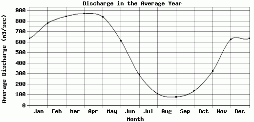
| Avg | 636.51 | 781.98 | 846.9 | 873.54 | 842.63 | 614.95 | 289.58 | 110.99 | 78.87 | 136.56 | 323.17 | 626.37 | 513.5 |
| |
|
|
|
|
|
|
|
|
|
|
|
|
|
| Std Dev | 540.85 |
399.41 |
378.05 |
419.1 |
477.58 |
480.73 |
254.48 |
98.34 |
33.53 |
132.83 |
312.75 |
381.07 |
218.54 |
| |
|
|
|
|
|
|
|
|
|
|
|
|
|
| | Jan | Feb | Mar | Apr | May | Jun | Jul | Aug | Sep | Oct | Nov | Dec | Avg Annual |
Click here for this table in tab-delimited format.
Tab-delimited format will open in most table browsing software, i.e. Excel, etc.
View this station on the map.
Return to start.