Results
| Country: | U.S.A.
| | Station: | WILLISTON, ND | | River: | MISSOURI RIVER | | Area: | 26183609.59 | | Lat: | 48.11 | | Lon: | -103.72 | | Source: | USGS | | PointID: | 6330000 | | Area Units: | km2 | | Discharge Units: | m3/sec | | Starting Year: | 1939 | | Ending Year: | 1942 | | Total Years: | 4 | | Total Usable Years: | 3 | |
| |
| Year | Jan | Feb | Mar | Apr | May | Jun | Jul | Aug | Sep | Oct | Nov | Dec | Avg Annual |
|---|
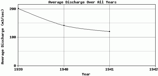
| 1939 | 175.23 | 591.95 | 416.34 | 166.39 | 137.84 | 126.65 | 156.27 | 287.84 | 127.28 | 100.03 | 73.15 | 62.15 | 201.76 |
| 1940 | 118.14 | 191.42 | 138.75 | 148.26 | 103.48 | 92.39 | 99.29 | 287.9 | 143.69 | 101.94 | 136.63 | 137.46 | 141.61 |
| 1941 | 137.33 | 118.56 | 157.05 | 183.79 | 103.84 | 109.57 | 251.62 | 89.46 | 78.3 | 88.35 | 53.07 | 75.2 | 120.51 |
| 1942 | -9999 | -9999 | -9999 | -9999 | -9999 | -9999 | -9999 | -9999 | -9999 | -9999 | -9999 | -9999 | -9999 |
| |
|
|
|
|
|
|
|
|
|
|
|
|
|
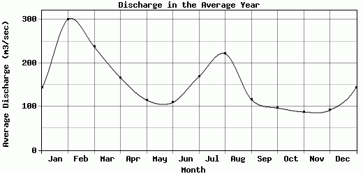
| Avg | 143.57 | 300.64 | 237.38 | 166.15 | 115.05 | 109.54 | 169.06 | 221.73 | 116.42 | 96.77 | 87.62 | 91.6 | 154.63 |
| |
|
|
|
|
|
|
|
|
|
|
|
|
|
| Std Dev | 23.72 |
208.12 |
126.76 |
14.51 |
16.11 |
13.99 |
62.84 |
93.53 |
27.78 |
6.01 |
35.61 |
32.86 |
34.42 |
| |
|
|
|
|
|
|
|
|
|
|
|
|
|
| | Jan | Feb | Mar | Apr | May | Jun | Jul | Aug | Sep | Oct | Nov | Dec | Avg Annual |
Click here for this table in tab-delimited format.
Tab-delimited format will open in most table browsing software, i.e. Excel, etc.
View this station on the map.
Return to start.