Results
| Country: | Togo
| | Station: | Correkope | | River: | Mono | | Area: | 9900 km2 | | Lat: | 7.66 | | Lon: | 1.16 | | Source: | RivDIS | | PointID: | 18 | | Area Units: | km2 | | Discharge Units: | m3/sec | | Starting Year: | 1966 | | Ending Year: | 1975 | | Total Years: | 10 | | Total Usable Years: | 8 | |
| |
| Year | Jan | Feb | Mar | Apr | May | Jun | Jul | Aug | Sep | Oct | Nov | Dec | Avg Annual |
|---|
| 1966 | -9999 | -9999 | -9999 | -9999 | -9999 | 11 | 59 | 307 | 311 | 89 | 19 | 2 | -9999 |
| 1967 | 0 | 0 | 0 | -9999 | -9999 | -9999 | -9999 | -9999 | -9999 | -9999 | -9999 | -9999 | -9999 |
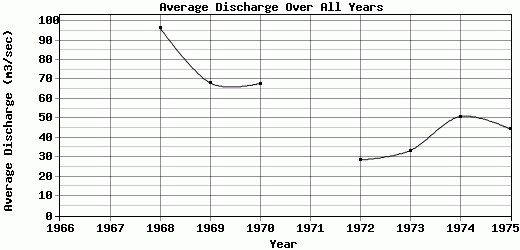
| 1968 | 0.4 | 0.2 | 0 | 0 | 2.7 | 14.4 | 200 | 361 | 399 | 154 | 22 | 3.5 | 96.43 |
| 1969 | 0.8 | 0.1 | 0 | 1.2 | 1.1 | 1.2 | 55.5 | 181 | 375 | 152 | 45.5 | 4.9 | 68.19 |
| 1970 | 1.3 | 0.5 | 1.6 | 0.1 | 0.7 | 1 | 4.9 | 153 | 537 | 105 | 7.9 | 1.5 | 67.88 |
| 1971 | 0.1 | 0 | -9999 | -9999 | -9999 | -9999 | -9999 | -9999 | -9999 | -9999 | -9999 | -9999 | -9999 |
| 1972 | 0 | 0 | 0.2 | 0.7 | 5.6 | 20.5 | 71.5 | 58 | 135 | 44.2 | 6.6 | 0.4 | 28.56 |
| 1973 | 0 | 0 | 0 | 0 | 0 | 0.4 | 16 | 101 | 176 | 100 | 6.9 | 0.2 | 33.37 |
| 1974 | 0 | 0 | 0 | 0 | 0 | 0 | 64.5 | 155 | 279 | 101 | 10 | 0.5 | 50.83 |
| 1975 | 0 | 0 | 0 | 0 | 0.3 | 1.7 | 69 | 168 | 178 | 110 | 6.6 | 1 | 44.55 |
| |
|
|
|
|
|
|
|
|
|
|
|
|
|
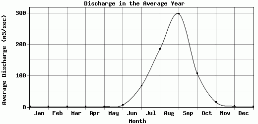
| Avg | 0.29 | 0.09 | 0.23 | 0.29 | 1.49 | 6.28 | 67.55 | 185.5 | 298.75 | 106.9 | 15.56 | 1.75 | 55.69 |
| |
|
|
|
|
|
|
|
|
|
|
|
|
|
| Std Dev | 0.44 |
0.16 |
0.52 |
0.44 |
1.89 |
7.41 |
55.19 |
94.39 |
127.29 |
32.79 |
12.62 |
1.56 |
21.86 |
| |
|
|
|
|
|
|
|
|
|
|
|
|
|
| | Jan | Feb | Mar | Apr | May | Jun | Jul | Aug | Sep | Oct | Nov | Dec | Avg Annual |
Click here for this table in tab-delimited format.
Tab-delimited format will open in most table browsing software, i.e. Excel, etc.
View this station on the map.
Return to start.