Results
| Country: | U.S.A.
| | Station: | OVERTON, NV | | River: | MUDDY R | | Area: | 21184.94 | | Lat: | 36.63 | | Lon: | -114.5 | | Source: | USGS | | PointID: | 9419500 | | Area Units: | km2 | | Discharge Units: | m3/sec | | Starting Year: | 1965 | | Ending Year: | 1968 | | Total Years: | 4 | | Total Usable Years: | 3 | |
| |
| Year | Jan | Feb | Mar | Apr | May | Jun | Jul | Aug | Sep | Oct | Nov | Dec | Avg Annual |
|---|
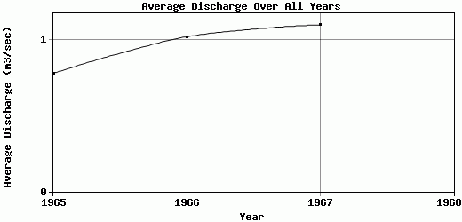
| 1965 | 0.35 | 0.34 | 0.34 | 1.15 | 0.98 | 0.59 | 1.28 | 1.2 | 1.04 | 1.06 | 0.55 | 0.44 | 0.78 |
| 1966 | 0.35 | 0.42 | 0.62 | 0.82 | 0.86 | 0.92 | 1.33 | 2.89 | 1.71 | 1.12 | 0.76 | 0.48 | 1.02 |
| 1967 | 0.62 | 0.49 | 0.72 | 0.64 | 3.51 | 1.21 | 1.05 | 1.31 | 1.09 | 1.15 | 0.79 | 0.59 | 1.1 |
| 1968 | -9999 | -9999 | -9999 | -9999 | -9999 | -9999 | -9999 | -9999 | -9999 | -9999 | -9999 | -9999 | -9999 |
| |
|
|
|
|
|
|
|
|
|
|
|
|
|
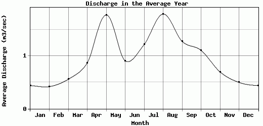
| Avg | 0.44 | 0.42 | 0.56 | 0.87 | 1.78 | 0.91 | 1.22 | 1.8 | 1.28 | 1.11 | 0.7 | 0.5 | 0.97 |
| |
|
|
|
|
|
|
|
|
|
|
|
|
|
| Std Dev | 0.13 |
0.06 |
0.16 |
0.21 |
1.22 |
0.25 |
0.12 |
0.77 |
0.3 |
0.04 |
0.11 |
0.06 |
0.14 |
| |
|
|
|
|
|
|
|
|
|
|
|
|
|
| | Jan | Feb | Mar | Apr | May | Jun | Jul | Aug | Sep | Oct | Nov | Dec | Avg Annual |
Click here for this table in tab-delimited format.
Tab-delimited format will open in most table browsing software, i.e. Excel, etc.
View this station on the map.
Return to start.