Results
| Country: | Canada
| | Station: | Peladeau | | River: | AuxFeuilles | | Area: | 41700 km2 | | Lat: | 58.65 | | Lon: | -70.41 | | Source: | RivDIS | | PointID: | 316 | | Area Units: | km2 | | Discharge Units: | m3/sec | | Starting Year: | 1966 | | Ending Year: | 1984 | | Total Years: | 19 | | Total Usable Years: | 18 | |
| |
| Year | Jan | Feb | Mar | Apr | May | Jun | Jul | Aug | Sep | Oct | Nov | Dec | Avg Annual |
|---|
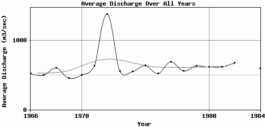
| 1966 | 69 | 42 | 25 | 17 | 594 | 2570 | 798 | 582 | 420 | 554 | 370 | 217 | 521.5 |
| 1967 | 105 | 57 | 33 | 21 | 420 | 2021 | 814 | 662 | 650 | 564 | 440 | 171 | 496.5 |
| 1968 | 83 | 48.5 | 38 | 35 | 982 | 1900 | 784 | 1010 | 745 | 929 | 541 | 167 | 605.21 |
| 1969 | 115 | 89.5 | 58 | 31 | 36 | 1980 | 1310 | 555 | 425 | 428 | 286 | 140 | 454.46 |
| 1970 | 93 | 70.5 | 53.5 | 39 | 32 | 1690 | 1530 | 756 | 600 | 637 | 362 | 152 | 501.25 |
| 1971 | 92 | 63.5 | 49.5 | 45.5 | 141 | 1720 | 1140 | 1490 | 1100 | 838 | 688 | 259 | 635.54 |
| 1972 | 428 | 328 | 271 | 236 | 286 | 4250 | 3260 | 1850 | 2320 | 1950 | 951 | 504 | 1386.17 |
| 1973 | 73.5 | 49.5 | 38 | 32.5 | 377 | 2150 | 1580 | 612 | 476 | 544 | 490 | 309 | 560.96 |
| 1974 | 212 | 137 | 87 | 76 | 558 | 2320 | 719 | 396 | 498 | 530 | 683 | 391 | 550.58 |
| 1975 | 154 | 107 | 74 | 56 | 216 | 2600 | 1000 | 790 | 708 | 793 | 708 | 442 | 637.33 |
| 1976 | 222 | 130 | 75.5 | 45 | 1070 | 1780 | 912 | 608 | 496 | 425 | 293 | 211 | 522.29 |
| 1977 | 152 | 112 | 81.5 | 61 | 261 | 2980 | 1510 | 936 | 750 | 534 | 657 | 287 | 693.46 |
| 1978 | 133 | 81.5 | 60 | 51.5 | 881 | 995 | 697 | 1200 | 942 | 729 | 725 | 224 | 559.92 |
| 1979 | 94.5 | 56.5 | 42.5 | 37 | 548 | 1800 | 1520 | 906 | 876 | 854 | 571 | 287 | 632.71 |
| 1980 | 156 | 102 | 79 | 75 | 1200 | 1890 | 873 | 611 | 691 | 769 | 602 | 360 | 617.33 |
| 1981 | 207 | 123 | 84 | 67.5 | 130 | 3040 | 1410 | 506 | 358 | 695 | 556 | 266 | 620.21 |
| 1982 | 160 | 116 | 95 | 85 | 240 | 2780 | 1230 | 1200 | 963 | 639 | 410 | 193 | 675.92 |
| 1983 | 118 | 93 | 86 | 85 | -9999 | -9999 | -9999 | 634 | 509 | 759 | 562 | 209 | -9999 |
| 1984 | 97 | 62 | 53 | 52.5 | 952 | 1300 | 778 | 782 | 1040 | 1180 | 566 | 243 | 592.13 |
| |
|
|
|
|
|
|
|
|
|
|
|
|
|
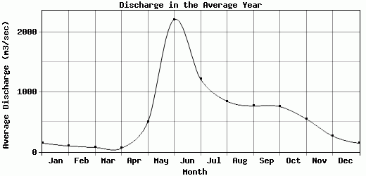
| Avg | 145.47 | 98.34 | 72.82 | 60.45 | 495.78 | 2209.22 | 1214.72 | 846.63 | 766.68 | 755.32 | 550.58 | 264.84 | 625.75 |
| |
|
|
|
|
|
|
|
|
|
|
|
|
|
| Std Dev | 80.56 |
61.4 |
50.94 |
45.83 |
363.9 |
727.27 |
583.48 |
358.74 |
424.97 |
334.48 |
163.36 |
97.02 |
195.02 |
| |
|
|
|
|
|
|
|
|
|
|
|
|
|
| | Jan | Feb | Mar | Apr | May | Jun | Jul | Aug | Sep | Oct | Nov | Dec | Avg Annual |
Click here for this table in tab-delimited format.
Tab-delimited format will open in most table browsing software, i.e. Excel, etc.
View this station on the map.
Return to start.