Results
| Country: | Canada
| | Station: | DeerCreek | | River: | NorthSaskatchewa | | Area: | 57100 km2 | | Lat: | 53.51 | | Lon: | -109.61 | | Source: | RivDIS | | PointID: | 1106 | | Area Units: | km2 | | Discharge Units: | m3/sec | | Starting Year: | 1973 | | Ending Year: | 1984 | | Total Years: | 12 | | Total Usable Years: | 12 | |
| |
| Year | Jan | Feb | Mar | Apr | May | Jun | Jul | Aug | Sep | Oct | Nov | Dec | Avg Annual |
|---|
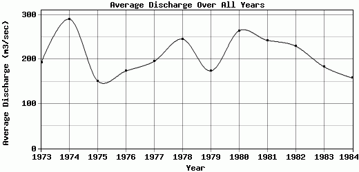
| 1973 | 75.5 | 110 | 112 | 279 | 365 | 360 | 294 | 214 | 170 | 150 | 115 | 76 | 193.38 |
| 1974 | 73 | 133 | 103 | 626 | 697 | 487 | 439 | 216 | 215 | 193 | 153 | 151 | 290.5 |
| 1975 | 124 | 111 | 108 | 218 | 278 | 219 | 204 | 139 | 126 | 96 | 75 | 114 | 151 |
| 1976 | 109 | 130 | 132 | 222 | 194 | 207 | 193 | 257 | 209 | 165 | 142 | 129 | 174.08 |
| 1977 | 114 | 98.5 | 100 | 179 | 294 | 416 | 239 | 251 | 241 | 188 | 94.5 | 136 | 195.92 |
| 1978 | 122 | 132 | 94.5 | 216 | 263 | 544 | 496 | 248 | 304 | 212 | 173 | 142 | 245.54 |
| 1979 | 111 | 127 | 199 | 218 | 347 | 226 | 237 | 187 | 140 | 111 | 97 | 89 | 174.08 |
| 1980 | 98.5 | 123 | 150 | 352 | 214 | 828 | 474 | 254 | 237 | 180 | 159 | 102 | 264.29 |
| 1981 | 111 | 99.5 | 126 | 227 | 388 | 317 | 434 | 512 | 230 | 168 | 163 | 140 | 242.96 |
| 1982 | 103 | 96.5 | 96 | 269 | 285 | 287 | 774 | 214 | 189 | 195 | 128 | 122 | 229.88 |
| 1983 | 146 | 107 | 115 | 290 | 295 | 260 | 373 | 149 | 127 | 120 | 115 | 105 | 183.5 |
| 1984 | 114 | 110 | 113 | 251 | 157 | 229 | 182 | 137 | 160 | 162 | 162 | 122 | 158.25 |
| |
|
|
|
|
|
|
|
|
|
|
|
|
|
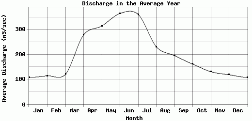
| Avg | 108.42 | 114.79 | 120.71 | 278.92 | 314.75 | 365 | 361.58 | 231.5 | 195.67 | 161.67 | 131.38 | 119 | 208.62 |
| |
|
|
|
|
|
|
|
|
|
|
|
|
|
| Std Dev | 19.11 |
13.01 |
28.15 |
113.32 |
132.41 |
174.98 |
166.53 |
94.7 |
51.54 |
34.71 |
30.66 |
21.72 |
42.88 |
| |
|
|
|
|
|
|
|
|
|
|
|
|
|
| | Jan | Feb | Mar | Apr | May | Jun | Jul | Aug | Sep | Oct | Nov | Dec | Avg Annual |
Click here for this table in tab-delimited format.
Tab-delimited format will open in most table browsing software, i.e. Excel, etc.
View this station on the map.
Return to start.