Results
| Country: | Gabon
| | Station: | Lastourville | | River: | Ogooue | | Area: | 47700 km2 | | Lat: | -0.81 | | Lon: | 12.73 | | Source: | RivDIS | | PointID: | 1488 | | Area Units: | km2 | | Discharge Units: | m3/sec | | Starting Year: | 1966 | | Ending Year: | 1974 | | Total Years: | 9 | | Total Usable Years: | 7 | |
| |
| Year | Jan | Feb | Mar | Apr | May | Jun | Jul | Aug | Sep | Oct | Nov | Dec | Avg Annual |
|---|
| 1966 | -9999 | -9999 | -9999 | -9999 | -9999 | -9999 | -9999 | -9999 | 790 | 1207 | 1643 | 1587 | -9999 |
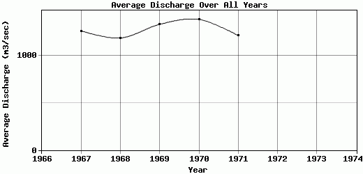
| 1967 | 1385 | 1592 | 1567 | 1162 | 1402 | 1072 | 1032 | 749 | 731 | 1348 | 1727 | 1385 | 1262.67 |
| 1968 | 1299 | 1099 | 1405 | 1676 | 1611 | 969 | 764 | 681 | 704 | 963 | 1278 | 1792 | 1186.75 |
| 1969 | 1321 | 1233 | 1637 | 1845 | 2151 | 1336 | 903 | 740 | 709 | 1022 | 1546 | 1537 | 1331.67 |
| 1970 | 1228 | 1369 | 2199 | 1841 | 1797 | 1175 | 844 | 740 | 817 | 1193 | 1949 | 1464 | 1384.67 |
| 1971 | 1431 | 1104 | 1305 | 1552 | 1533 | 1123 | 803 | 686 | 706 | 945 | 1991 | 1378 | 1213.08 |
| 1972 | 1163 | 1137 | 1163 | 1387 | 1391 | 1001 | 738 | 660 | 661 | 802 | -9999 | -9999 | -9999 |
| 1973 | -9999 | -9999 | 1028 | 1302 | 2107 | 1194 | 827 | 701 | 711 | -9999 | -9999 | -9999 | -9999 |
| 1974 | -9999 | -9999 | -9999 | -9999 | -9999 | 1080 | -9999 | -9999 | -9999 | -9999 | -9999 | -9999 | -9999 |
| |
|
|
|
|
|
|
|
|
|
|
|
|
|
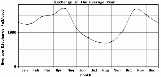
| Avg | 1304.5 | 1255.67 | 1472 | 1537.86 | 1713.14 | 1118.75 | 844.43 | 708.14 | 728.63 | 1068.57 | 1689 | 1523.83 | 1275.77 |
| |
|
|
|
|
|
|
|
|
|
|
|
|
|
| Std Dev | 90.06 |
177.06 |
356.53 |
246.45 |
292.12 |
109.56 |
91.36 |
32.28 |
47.39 |
174.18 |
242.12 |
141.54 |
73.5 |
| |
|
|
|
|
|
|
|
|
|
|
|
|
|
| | Jan | Feb | Mar | Apr | May | Jun | Jul | Aug | Sep | Oct | Nov | Dec | Avg Annual |
Click here for this table in tab-delimited format.
Tab-delimited format will open in most table browsing software, i.e. Excel, etc.
View this station on the map.
Return to start.