Results
| Country: | U.S.A.
| | Station: | POMEROY, OH | | River: | OHIO R | | Area: | 13027450.99 | | Lat: | 38.84 | | Lon: | -82.14 | | Source: | USGS | | PointID: | 3160000 | | Area Units: | km2 | | Discharge Units: | m3/sec | | Starting Year: | 1978 | | Ending Year: | 1985 | | Total Years: | 8 | | Total Usable Years: | 3 | |
| |
| Year | Jan | Feb | Mar | Apr | May | Jun | Jul | Aug | Sep | Oct | Nov | Dec | Avg Annual |
|---|
| 1978 | -9999 | -9999 | -9999 | -9999 | -9999 | -9999 | -9999 | -9999 | -9999 | -9999 | -9999 | -9999 | -9999 |
| 1979 | -9999 | -9999 | -9999 | -9999 | -9999 | -9999 | -9999 | -9999 | -9999 | -9999 | -9999 | -9999 | -9999 |
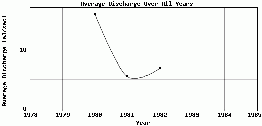
| 1980 | 18.06 | 50.96 | 18.48 | 27.62 | 36.41 | 10.49 | 2.24 | 2.46 | 6.75 | 4.83 | 7.95 | 8.4 | 16.22 |
| 1981 | 8.24 | 6.61 | 8.41 | 14.36 | 6.33 | 0.59 | 0.97 | 2.22 | 2.09 | 5.53 | 5.8 | 5.35 | 5.54 |
| 1982 | 6.42 | 7.71 | 10.96 | 10.23 | 8.92 | 0.86 | 1.14 | 4.86 | 4.19 | 6.06 | 8.03 | 13.88 | 6.94 |
| 1983 | -9999 | -9999 | -9999 | -9999 | -9999 | -9999 | -9999 | -9999 | -9999 | -9999 | -9999 | -9999 | -9999 |
| 1984 | -9999 | -9999 | -9999 | -9999 | -9999 | -9999 | -9999 | -9999 | -9999 | -9999 | -9999 | -9999 | -9999 |
| 1985 | -9999 | -9999 | -9999 | -9999 | -9999 | -9999 | -9999 | -9999 | -9999 | -9999 | -9999 | -9999 | -9999 |
| |
|
|
|
|
|
|
|
|
|
|
|
|
|
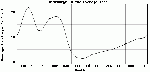
| Avg | 10.91 | 21.76 | 12.62 | 17.4 | 17.22 | 3.98 | 1.45 | 3.18 | 4.34 | 5.47 | 7.26 | 9.21 | 9.57 |
| |
|
|
|
|
|
|
|
|
|
|
|
|
|
| Std Dev | 5.11 |
20.65 |
4.27 |
7.42 |
13.61 |
4.6 |
0.56 |
1.19 |
1.91 |
0.5 |
1.03 |
3.53 |
4.74 |
| |
|
|
|
|
|
|
|
|
|
|
|
|
|
| | Jan | Feb | Mar | Apr | May | Jun | Jul | Aug | Sep | Oct | Nov | Dec | Avg Annual |
Click here for this table in tab-delimited format.
Tab-delimited format will open in most table browsing software, i.e. Excel, etc.
View this station on the map.
Return to start.