Results
| Country: | U.S.A.
| | Station: | MILLERS FERRY L&D NR CAMDEN AL | | River: | ALABAMA RIVER | | Area: | 53446.66 | | Lat: | 32.1 | | Lon: | -87.39 | | Source: | USGS | | PointID: | 2427506 | | Area Units: | km2 | | Discharge Units: | m3/sec | | Starting Year: | 1913 | | Ending Year: | 1914 | | Total Years: | 2 | | Total Usable Years: | 1 | |
| |
| Year | Jan | Feb | Mar | Apr | May | Jun | Jul | Aug | Sep | Oct | Nov | Dec | Avg Annual |
|---|
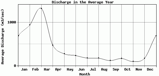
| 1913 | 690.02 | 939.92 | 1320.94 | 471.03 | 271.06 | 231.63 | 173.19 | 170.12 | 114.81 | 162.78 | 92.09 | 166.98 | 400.38 |
| 1914 | -9999 | -9999 | -9999 | -9999 | -9999 | -9999 | -9999 | -9999 | -9999 | -9999 | -9999 | -9999 | -9999 |
| |
|
|
|
|
|
|
|
|
|
|
|
|
|
| Avg | 690.02 | 939.92 | 1320.94 | 471.03 | 271.06 | 231.63 | 173.19 | 170.12 | 114.81 | 162.78 | 92.09 | 166.98 | 400.38 |
| |
|
|
|
|
|
|
|
|
|
|
|
|
|
| Std Dev | 0 |
0 |
0 |
0 |
0 |
0 |
0 |
0 |
0 |
0 |
0 |
0 |
0 |
| |
|
|
|
|
|
|
|
|
|
|
|
|
|
| | Jan | Feb | Mar | Apr | May | Jun | Jul | Aug | Sep | Oct | Nov | Dec | Avg Annual |
Click here for this table in tab-delimited format.
Tab-delimited format will open in most table browsing software, i.e. Excel, etc.
View this station on the map.
Return to start.