Results
| Country: | U.S.A.
| | Station: | FORT YUKON AK | | River: | PORCUPINE R | | Area: | 76400.47 | | Lat: | 66.99 | | Lon: | -143.14 | | Source: | USGS | | PointID: | 15389000 | | Area Units: | km2 | | Discharge Units: | m3/sec | | Starting Year: | 1981 | | Ending Year: | 1986 | | Total Years: | 6 | | Total Usable Years: | 5 | |
| |
| Year | Jan | Feb | Mar | Apr | May | Jun | Jul | Aug | Sep | Oct | Nov | Dec | Avg Annual |
|---|
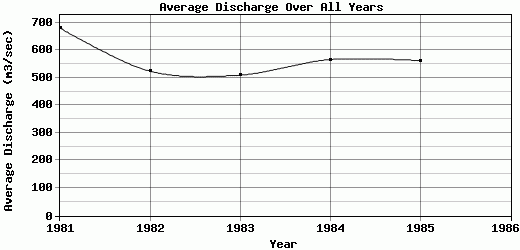
| 1981 | 105.05 | 105.78 | 77.83 | 155.18 | 1292.26 | 1560.74 | 1823.16 | 1666.68 | 733.22 | 347.22 | 176.89 | 128.52 | 681.04 |
| 1982 | 103.68 | 80.7 | 63.03 | 61.64 | 393.7 | 1157.41 | 1323.5 | 1125.74 | 1347.79 | 354.15 | 160.37 | 116.56 | 524.02 |
| 1983 | 94.56 | 91.63 | 87.42 | 125.11 | 733.5 | 1381.78 | 1263.58 | 1334.74 | 446.07 | 304.18 | 154.14 | 101.3 | 509.83 |
| 1984 | 74.63 | 65.36 | 64.49 | 162.95 | 874.45 | 1418.49 | 1485.73 | 1511.76 | 537.08 | 388.48 | 123.84 | 85.32 | 566.05 |
| 1985 | 83.85 | 80.7 | 74.17 | 70.79 | 546.24 | 1373.19 | 1663.85 | 1308.52 | 844.79 | 460.2 | 137.24 | 105.96 | 562.46 |
| 1986 | -9999 | -9999 | -9999 | -9999 | -9999 | -9999 | -9999 | -9999 | -9999 | -9999 | -9999 | -9999 | -9999 |
| |
|
|
|
|
|
|
|
|
|
|
|
|
|
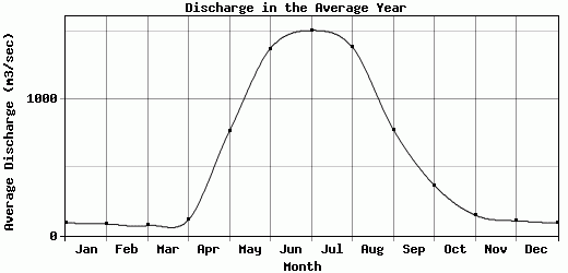
| Avg | 92.35 | 84.83 | 73.39 | 115.13 | 768.03 | 1378.32 | 1511.96 | 1389.49 | 781.79 | 370.85 | 150.5 | 107.53 | 568.68 |
| |
|
|
|
|
|
|
|
|
|
|
|
|
|
| Std Dev | 11.67 |
13.4 |
8.99 |
41.99 |
308.76 |
129.41 |
208.72 |
184.88 |
316 |
52.11 |
18.4 |
14.54 |
60.21 |
| |
|
|
|
|
|
|
|
|
|
|
|
|
|
| | Jan | Feb | Mar | Apr | May | Jun | Jul | Aug | Sep | Oct | Nov | Dec | Avg Annual |
Click here for this table in tab-delimited format.
Tab-delimited format will open in most table browsing software, i.e. Excel, etc.
View this station on the map.
Return to start.