Results
| Country: | U.S.A.
| | Station: | FortYukon, Alaska | | River: | Porcupine | | Area: | 76405 km2 | | Lat: | 66.98 | | Lon: | -143.13 | | Source: | RivDIS | | PointID: | 1200 | | Area Units: | km2 | | Discharge Units: | m3/sec | | Starting Year: | 1965 | | Ending Year: | 1979 | | Total Years: | 15 | | Total Usable Years: | 14 | |
| |
| Year | Jan | Feb | Mar | Apr | May | Jun | Jul | Aug | Sep | Oct | Nov | Dec | Avg Annual |
|---|
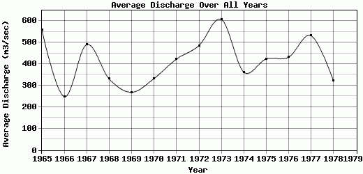
| 1965 | 31 | 11 | 3 | 3 | 584 | 2271 | 1046 | 1018 | 1207 | 393 | 110 | 40 | 559.75 |
| 1966 | 7 | 1 | 0 | 9 | 410 | 1542 | 436 | 154 | 261 | 117 | 35 | 11 | 248.58 |
| 1967 | 5 | 1 | 0 | 4 | 581 | 2296 | 726 | 1215 | 835 | 170 | 31 | 20 | 490.33 |
| 1968 | 17 | 16 | 14.5 | 14 | 580 | 2450 | 460 | 160 | 145 | 57 | 29.5 | 26.5 | 330.79 |
| 1969 | 24 | 21 | 20 | 22 | 648 | 557 | 167 | 1080 | 498 | 99.5 | 48 | 41 | 268.79 |
| 1970 | 26 | 20 | 20 | 19.5 | 680 | 1420 | 619 | 471 | 563 | 72 | 47.2 | 33.2 | 332.58 |
| 1971 | 24.5 | 23 | 22 | 21 | 1720 | 1230 | 402 | 772 | 649 | 136 | 43.8 | 32.6 | 422.99 |
| 1972 | 29.5 | 26 | 21 | 16 | 614 | 2590 | 819 | 632 | 859 | 136 | 44 | 32.5 | 484.92 |
| 1973 | 9.18 | 7.08 | 7.08 | 7.08 | 2410 | 1780 | 850 | 1260 | 646 | 209 | 68.5 | 35 | 607.41 |
| 1974 | 28.5 | 25.5 | 22.5 | 22.5 | 732 | 801 | 609 | 1180 | 503 | 266 | 110 | 49 | 362.42 |
| 1975 | 34.5 | 31 | 27 | 26 | 1540 | 1830 | 309 | 440 | 586 | 166 | 60.5 | 35 | 423.75 |
| 1976 | 27 | 23 | 19 | 18 | 1700 | 1430 | 489 | 721 | 323 | 254 | 122 | 55 | 431.75 |
| 1977 | 36 | 29 | 25 | 23 | 2060 | 2790 | 583 | 230 | 295 | 225 | 55 | 33 | 532 |
| 1978 | 24 | 19 | 16 | 15 | 274 | 1880 | 638 | 220 | 375 | 252 | 90 | 55 | 321.5 |
| 1979 | 36 | 29 | 23 | 22 | 1050 | 832 | 538 | 670 | 601 | -9999 | -9999 | -9999 | -9999 |
| |
|
|
|
|
|
|
|
|
|
|
|
|
|
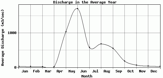
| Avg | 23.95 | 18.84 | 16.01 | 16.14 | 1038.87 | 1713.27 | 579.4 | 681.53 | 556.4 | 182.32 | 63.89 | 35.63 | 415.54 |
| |
|
|
|
|
|
|
|
|
|
|
|
|
|
| Std Dev | 9.76 |
9.43 |
8.79 |
7.07 |
644.92 |
660.42 |
215.27 |
384.87 |
262.1 |
87.68 |
30.3 |
11.78 |
105.93 |
| |
|
|
|
|
|
|
|
|
|
|
|
|
|
| | Jan | Feb | Mar | Apr | May | Jun | Jul | Aug | Sep | Oct | Nov | Dec | Avg Annual |
Click here for this table in tab-delimited format.
Tab-delimited format will open in most table browsing software, i.e. Excel, etc.
View this station on the map.
Return to start.