Results
| Country: | U.S.A.
| | Station: | Agness,Oregon | | River: | Rogue | | Area: | 10200 km2 | | Lat: | 42.58 | | Lon: | -124.06 | | Source: | RivDIS | | PointID: | 345 | | Area Units: | km2 | | Discharge Units: | m3/sec | | Starting Year: | 1965 | | Ending Year: | 1984 | | Total Years: | 20 | | Total Usable Years: | 20 | |
| |
| Year | Jan | Feb | Mar | Apr | May | Jun | Jul | Aug | Sep | Oct | Nov | Dec | Avg Annual |
|---|
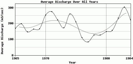
| 1965 | 804 | 304 | 155 | 214 | 129 | 32 | 49 | 46 | 40 | 46 | 79 | 126 | 168.67 |
| 1966 | 693 | 175 | 370 | 254 | 133 | 70 | 45 | 31 | 38 | 40 | 179 | 351 | 198.25 |
| 1967 | 431 | 261 | 235 | 184 | 207 | 114 | 47 | 32 | 33 | 50 | 49 | 121 | 147 |
| 1968 | 226 | 406 | 182 | 93.5 | 71.5 | 42 | 24 | 28 | 26 | 40 | 130 | 697 | 163.83 |
| 1969 | 418 | 380 | 192 | 202 | 196 | 103 | 46 | 32.5 | 33.5 | 50.5 | 52.5 | 298 | 167 |
| 1970 | 861 | 265 | 229 | 110 | 123 | 685 | 35.5 | 28 | 31 | 43 | 240 | 392 | 253.54 |
| 1971 | 813 | 269 | 474 | 321 | 249 | 159 | 77 | 46 | 50.5 | 450 | 213 | 186 | 275.63 |
| 1972 | 600 | 384 | 716 | 243 | 159 | 113 | 56.5 | 44.5 | 46.5 | 52.5 | 63.5 | 193 | 222.63 |
| 1973 | 234 | 135 | 150 | 130 | 84.5 | 42 | 28 | 25 | 32 | 46 | 573 | 587 | 172.21 |
| 1974 | 924 | 415 | 622 | 394 | 195 | 161 | 69.5 | 46.5 | 42.5 | 47 | 62.5 | 149 | 260.67 |
| 1975 | 257 | 430 | 532 | 249 | 256 | 174 | 73 | 48.5 | 46 | 72 | 127 | 264 | 210.71 |
| 1976 | 285 | 187 | 183 | 167 | 139 | 80 | 50 | 60 | 45 | 45 | 46 | 44 | 110.92 |
| 1977 | 46 | 43 | 75 | 41 | 60 | 36 | 26 | 25 | 41 | 47 | 182 | 384 | 83.83 |
| 1978 | 342 | 365 | 146 | 153 | 102 | 70 | 70 | 55 | 60 | 41 | 47 | 75 | 127.17 |
| 1979 | 120 | 199 | 165 | 178 | 210 | 65 | 65 | 50 | 40 | 60 | 141 | 229 | 126.83 |
| 1980 | 469 | 187 | 232 | 202 | 113 | 78.5 | 63 | 54 | 38 | 42 | 72 | 234 | 148.71 |
| 1981 | 88 | 140 | 99 | 93 | 73 | 60.5 | 56.5 | 55 | 54 | 61.5 | 262 | 828 | 155.88 |
| 1982 | 378 | 479 | 297 | 427 | 175 | 116 | 78.5 | 69.5 | 66.5 | 99 | 136 | 481 | 233.54 |
| 1983 | 338 | 857 | 502 | 334 | 231 | 142 | 85.5 | 82.5 | 90 | 81 | 285 | 621 | 304.08 |
| 1984 | 228 | 344 | 342 | 264 | 208 | 152 | 97.5 | 95.5 | 79.5 | 76 | 542 | 251 | 223.29 |
| |
|
|
|
|
|
|
|
|
|
|
|
|
|
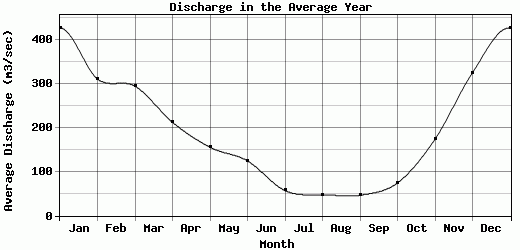
| Avg | 427.75 | 311.25 | 294.9 | 212.68 | 155.7 | 124.75 | 57.13 | 47.73 | 46.65 | 74.47 | 174.08 | 325.55 | 187.72 |
| |
|
|
|
|
|
|
|
|
|
|
|
|
|
| Std Dev | 261.46 |
169.51 |
178.53 |
98.77 |
59.89 |
135.77 |
19.78 |
18.51 |
16.02 |
87.54 |
147.36 |
211.95 |
57.45 |
| |
|
|
|
|
|
|
|
|
|
|
|
|
|
| | Jan | Feb | Mar | Apr | May | Jun | Jul | Aug | Sep | Oct | Nov | Dec | Avg Annual |
Click here for this table in tab-delimited format.
Tab-delimited format will open in most table browsing software, i.e. Excel, etc.
View this station on the map.
Return to start.