Results
| Country: | U.S.A.
| | Station: | ORIN, WY | | River: | NORTH PLATTE RIVER | | Area: | 38557.63 | | Lat: | 42.65 | | Lon: | -105.16 | | Source: | USGS | | PointID: | 6652000 | | Area Units: | km2 | | Discharge Units: | m3/sec | | Starting Year: | 1977 | | Ending Year: | 1979 | | Total Years: | 3 | | Total Usable Years: | 2 | |
| |
| Year | Jan | Feb | Mar | Apr | May | Jun | Jul | Aug | Sep | Oct | Nov | Dec | Avg Annual |
|---|
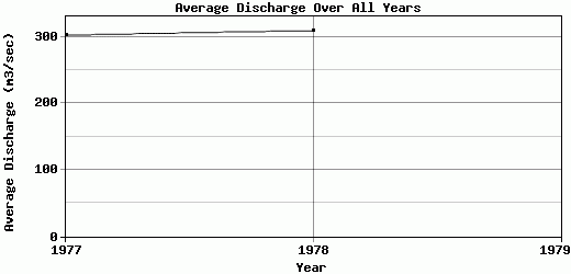
| 1977 | 145.7 | 371.98 | 542.64 | 582.24 | 194.05 | 131.38 | 99.75 | 132.81 | 97.63 | 272.65 | 608.84 | 449.1 | 302.4 |
| 1978 | 529.77 | 294.22 | 953.37 | 395.03 | 524.04 | 172.76 | 144.99 | 96.65 | 93.6 | 97.34 | 65 | 344.94 | 309.31 |
| 1979 | -9999 | -9999 | -9999 | -9999 | -9999 | -9999 | -9999 | -9999 | -9999 | -9999 | -9999 | -9999 | -9999 |
| |
|
|
|
|
|
|
|
|
|
|
|
|
|
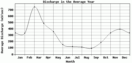
| Avg | 337.74 | 333.1 | 748.01 | 488.64 | 359.04 | 152.07 | 122.37 | 114.73 | 95.62 | 185 | 336.92 | 397.02 | 305.86 |
| |
|
|
|
|
|
|
|
|
|
|
|
|
|
| Std Dev | 192.04 |
38.88 |
205.37 |
93.61 |
165 |
20.69 |
22.62 |
18.08 |
2.02 |
87.66 |
271.92 |
52.08 |
3.46 |
| |
|
|
|
|
|
|
|
|
|
|
|
|
|
| | Jan | Feb | Mar | Apr | May | Jun | Jul | Aug | Sep | Oct | Nov | Dec | Avg Annual |
Click here for this table in tab-delimited format.
Tab-delimited format will open in most table browsing software, i.e. Excel, etc.
View this station on the map.
Return to start.