Results
| Country: | Canada
| | Station: | Mactaquac | | River: | SaintJohn | | Area: | 39900 km2 | | Lat: | 45.96 | | Lon: | -66.83 | | Source: | RivDIS | | PointID: | 1026 | | Area Units: | km2 | | Discharge Units: | m3/sec | | Starting Year: | 1973 | | Ending Year: | 1984 | | Total Years: | 12 | | Total Usable Years: | 11 | |
| |
| Year | Jan | Feb | Mar | Apr | May | Jun | Jul | Aug | Sep | Oct | Nov | Dec | Avg Annual |
|---|
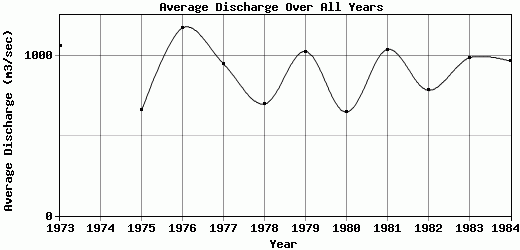
| 1973 | 402 | 730 | 960 | 3620 | 2890 | 909 | 620 | 396 | 292 | 286 | 225 | 1390 | 1060 |
| 1974 | 561 | 343 | 660 | 1580 | 4078 | 869 | 425 | 283 | 239 | 303 | -9999 | 646 | -9999 |
| 1975 | 350 | 219 | 365 | 1160 | 3160 | 958 | 272 | 166 | 173 | 246 | 444 | 390 | 658.58 |
| 1976 | 291 | 603 | 668 | 4160 | 2770 | 601 | 750 | 1130 | 570 | 1230 | 906 | 414 | 1174.42 |
| 1977 | 289 | 216 | 502 | 3000 | 2480 | 1170 | 372 | 404 | 373 | 1460 | 698 | 417 | 948.42 |
| 1978 | 753 | 452 | 318 | 1690 | 3050 | 663 | 386 | 204 | 189 | 241 | 246 | 185 | 698.08 |
| 1979 | 501 | 478 | 2030 | 2780 | 2310 | 1120 | 339 | 336 | 738 | 500 | 686 | 507 | 1027.08 |
| 1980 | 461 | 216 | 276 | 1970 | 1190 | 345 | 519 | 416 | 407 | 752 | 544 | 675 | 647.58 |
| 1981 | 317 | 1050 | 858 | 2500 | 1380 | 769 | 450 | 1230 | 638 | 1410 | 1120 | 755 | 1039.75 |
| 1982 | 383 | 310 | 324 | 2410 | 2520 | 433 | 247 | 278 | 501 | 362 | 915 | 731 | 784.5 |
| 1983 | 469 | 403 | 725 | 3350 | 2440 | 1050 | 307 | 231 | 210 | 289 | 1190 | 1170 | 986.17 |
| 1984 | 436 | 477 | 497 | 2940 | 3010 | 1670 | 1110 | 397 | 216 | 174 | 350 | 324 | 966.75 |
| |
|
|
|
|
|
|
|
|
|
|
|
|
|
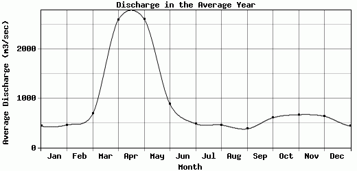
| Avg | 434.42 | 458.08 | 681.92 | 2596.67 | 2606.5 | 879.75 | 483.08 | 455.92 | 378.83 | 604.42 | 665.82 | 633.67 | 908.3 |
| |
|
|
|
|
|
|
|
|
|
|
|
|
|
| Std Dev | 125.89 |
234.28 |
458.3 |
852.91 |
740.96 |
344.6 |
234.98 |
334.04 |
184.61 |
465.59 |
321.45 |
335.85 |
172.2 |
| |
|
|
|
|
|
|
|
|
|
|
|
|
|
| | Jan | Feb | Mar | Apr | May | Jun | Jul | Aug | Sep | Oct | Nov | Dec | Avg Annual |
Click here for this table in tab-delimited format.
Tab-delimited format will open in most table browsing software, i.e. Excel, etc.
View this station on the map.
Return to start.