Results
| Country: | U.S.A.
| | Station: | OASIS UTAH | | River: | SEVIER RIVER | | Area: | 20925.96 | | Lat: | 39.31 | | Lon: | -112.62 | | Source: | USGS | | PointID: | 10231500 | | Area Units: | km2 | | Discharge Units: | m3/sec | | Starting Year: | 1984 | | Ending Year: | 1985 | | Total Years: | 2 | | Total Usable Years: | 1 | |
| |
| Year | Jan | Feb | Mar | Apr | May | Jun | Jul | Aug | Sep | Oct | Nov | Dec | Avg Annual |
|---|
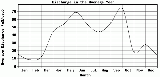
| 1984 | 15.2 | 8.45 | 12.26 | 44.12 | 55.08 | 69.41 | 53.39 | 43.99 | 55.49 | 74.09 | 18.39 | 27.54 | 39.78 |
| 1985 | -9999 | -9999 | -9999 | -9999 | -9999 | -9999 | -9999 | -9999 | -9999 | -9999 | -9999 | -9999 | -9999 |
| |
|
|
|
|
|
|
|
|
|
|
|
|
|
| Avg | 15.2 | 8.45 | 12.26 | 44.12 | 55.08 | 69.41 | 53.39 | 43.99 | 55.49 | 74.09 | 18.39 | 27.54 | 39.78 |
| |
|
|
|
|
|
|
|
|
|
|
|
|
|
| Std Dev | 0 |
0 |
0 |
0 |
0 |
0 |
0 |
0 |
0 |
0 |
0 |
0 |
0 |
| |
|
|
|
|
|
|
|
|
|
|
|
|
|
| | Jan | Feb | Mar | Apr | May | Jun | Jul | Aug | Sep | Oct | Nov | Dec | Avg Annual |
Click here for this table in tab-delimited format.
Tab-delimited format will open in most table browsing software, i.e. Excel, etc.
View this station on the map.
Return to start.