Results
| Country: | U.S.A.
| | Station: | VERENDRYE, ND | | River: | SOURIS RIVER | | Area: | 23334524.64 | | Lat: | 48.16 | | Lon: | -100.72 | | Source: | USGS | | PointID: | 5120000 | | Area Units: | km2 | | Discharge Units: | m3/sec | | Starting Year: | 1952 | | Ending Year: | 1959 | | Total Years: | 8 | | Total Usable Years: | 7 | |
| |
| Year | Jan | Feb | Mar | Apr | May | Jun | Jul | Aug | Sep | Oct | Nov | Dec | Avg Annual |
|---|
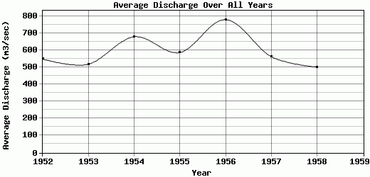
| 1952 | 372.14 | 450.04 | 298.09 | 732.69 | 1793.75 | 1087.66 | 530.72 | 231.85 | 228.28 | 279.52 | 288.53 | 286.46 | 548.31 |
| 1953 | 310.88 | 297.48 | 287.23 | 334.99 | 835.08 | 1903.75 | 752.23 | 262.07 | 292.03 | 307.34 | 313.75 | 321.41 | 518.19 |
| 1954 | 258.14 | 386.89 | 405.21 | 572.29 | 1713.73 | 1698.74 | 1273.17 | 385.29 | 296.63 | 319.93 | 380.77 | 452.34 | 678.59 |
| 1955 | 447.96 | 461.57 | 347.66 | 373.22 | 860.11 | 1563.95 | 1099.89 | 307.38 | 329.05 | 350.45 | 384.3 | 513.73 | 586.61 |
| 1956 | 470.88 | 481.29 | 573.65 | 1169.96 | 2000.18 | 1972.94 | 745.29 | 280.43 | 340.28 | 371.18 | 428.07 | 509.8 | 778.66 |
| 1957 | 465.49 | 398.36 | 402.65 | 383.13 | 1584.93 | 1322.12 | 435.86 | 219.16 | 261 | 362.9 | 470.53 | 438.82 | 562.08 |
| 1958 | 295.16 | 256.26 | 334.16 | 395.24 | 1463.17 | 1205.08 | 464.42 | 186.16 | 244.35 | 263.7 | 334.74 | 566.71 | 500.76 |
| 1959 | -9999 | -9999 | -9999 | -9999 | -9999 | -9999 | -9999 | -9999 | -9999 | -9999 | -9999 | -9999 | -9999 |
| |
|
|
|
|
|
|
|
|
|
|
|
|
|
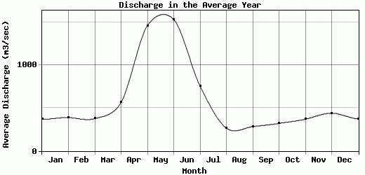
| Avg | 374.38 | 390.27 | 378.38 | 565.93 | 1464.42 | 1536.32 | 757.37 | 267.48 | 284.52 | 322.15 | 371.53 | 441.32 | 596.17 |
| |
|
|
|
|
|
|
|
|
|
|
|
|
|
| Std Dev | 81.81 |
78.91 |
90.31 |
279.21 |
419.77 |
318.41 |
298.59 |
60.81 |
38.96 |
38.4 |
59.55 |
95.73 |
91.67 |
| |
|
|
|
|
|
|
|
|
|
|
|
|
|
| | Jan | Feb | Mar | Apr | May | Jun | Jul | Aug | Sep | Oct | Nov | Dec | Avg Annual |
Click here for this table in tab-delimited format.
Tab-delimited format will open in most table browsing software, i.e. Excel, etc.
View this station on the map.
Return to start.