Results
| Country: | U.S.A.
| | Station: | WESTHOPE, ND | | River: | SOURIS RIVER | | Area: | 23334524.64 | | Lat: | 48.99 | | Lon: | -100.95 | | Source: | USGS | | PointID: | 5124000 | | Area Units: | km2 | | Discharge Units: | m3/sec | | Starting Year: | 1984 | | Ending Year: | 1996 | | Total Years: | 13 | | Total Usable Years: | 12 | |
| |
| Year | Jan | Feb | Mar | Apr | May | Jun | Jul | Aug | Sep | Oct | Nov | Dec | Avg Annual |
|---|
| 1984 | 348.94 | 298.61 | 264.79 | 246.75 | 235.06 | 598.53 | 325.56 | 195.69 | 252.76 | 287.75 | 273.46 | 317.54 | 303.79 |
| 1985 | 321.55 | 315.73 | 239.63 | 239.34 | 459.37 | 590.41 | 292.15 | 295.57 | 349.62 | 319.25 | 317.72 | 322.3 | 338.55 |
| 1986 | 366.48 | 365.49 | 302.35 | 352.29 | 384.31 | 658.65 | 251.39 | 155.39 | 265.2 | 284.2 | 303.28 | 293.14 | 331.85 |
| 1987 | 296.11 | 243.53 | 173.41 | 230.27 | 402.01 | 257.45 | 196.61 | 224.31 | 323.03 | 307.85 | 271.83 | 279.06 | 267.12 |
| 1988 | 172.81 | 268.04 | 359.26 | 336.13 | 264.81 | 289.34 | 191.37 | 120.19 | 140.97 | 223.27 | 282.44 | 270.58 | 243.27 |
| 1989 | 181.27 | 214.3 | 250.92 | 260.97 | 466.04 | 558.51 | 372.6 | 340.93 | 370.7 | 277.31 | 325.73 | 366.48 | 332.15 |
| 1990 | 350.48 | 276.09 | 275.07 | 434.38 | 532.63 | 953.91 | 494.36 | 214.61 | 252.65 | 330.97 | 338.02 | 353.23 | 400.53 |
| 1991 | 380.54 | 438.31 | 363.54 | 406.35 | 759.9 | 942.58 | 645.08 | 218.24 | 282.96 | 341.83 | 345.28 | 340.35 | 455.41 |
| 1992 | 293.8 | 194.65 | 164.92 | 209.27 | 224.87 | 333.86 | 238.58 | 226.64 | 273.76 | 334.1 | 272.59 | 248.55 | 251.3 |
| 1993 | 386.76 | 236.68 | 209.95 | 179.55 | 381.48 | 418.34 | 468.33 | 212.55 | 241.87 | 249.17 | 329.84 | 377.67 | 307.68 |
| 1994 | 380.91 | 289.57 | 204.49 | 206.57 | 322.19 | 354.33 | 177.81 | 117.92 | 113.59 | 199.9 | 307.01 | 193.46 | 238.98 |
| 1995 | 222.64 | 271.97 | 220.74 | 195.17 | 166.42 | 743.13 | 415.63 | 202.77 | 176.75 | 229.07 | 334.5 | 488.7 | 305.62 |
| 1996 | -9999 | -9999 | -9999 | -9999 | -9999 | -9999 | -9999 | -9999 | -9999 | -9999 | -9999 | -9999 | -9999 |
| |
|
|
|
|
|
|
|
|
|
|
|
|
|
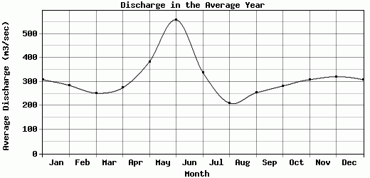
| Avg | 308.52 | 284.41 | 252.42 | 274.75 | 383.26 | 558.25 | 339.12 | 210.4 | 253.65 | 282.06 | 308.48 | 320.92 | 314.69 |
| |
|
|
|
|
|
|
|
|
|
|
|
|
|
| Std Dev | 74.07 |
63.82 |
61.97 |
82.22 |
155.19 |
228.3 |
138.36 |
61.12 |
74.99 |
45.53 |
26.31 |
71.54 |
61.71 |
| |
|
|
|
|
|
|
|
|
|
|
|
|
|
| | Jan | Feb | Mar | Apr | May | Jun | Jul | Aug | Sep | Oct | Nov | Dec | Avg Annual |
Click here for this table in tab-delimited format.
Tab-delimited format will open in most table browsing software, i.e. Excel, etc.
View this station on the map.
Return to start.