Results
| Country: | U.S.A.
| | Station: | JUNEAU AK | | River: | TAKU R | | Area: | 17092.99 | | Lat: | 58.54 | | Lon: | -133.7 | | Source: | USGS | | PointID: | 15041200 | | Area Units: | km2 | | Discharge Units: | m3/sec | | Starting Year: | 1990 | | Ending Year: | 1993 | | Total Years: | 4 | | Total Usable Years: | 1 | |
| |
| Year | Jan | Feb | Mar | Apr | May | Jun | Jul | Aug | Sep | Oct | Nov | Dec | Avg Annual |
|---|
| 1990 | -9999 | -9999 | -9999 | -9999 | -9999 | -9999 | -9999 | -9999 | -9999 | -9999 | -9999 | -9999 | -9999 |
| 1991 | -9999 | -9999 | -9999 | -9999 | -9999 | -9999 | -9999 | -9999 | -9999 | -9999 | -9999 | -9999 | -9999 |
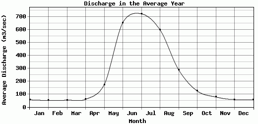
| 1992 | 55.63 | 50.97 | 52.89 | 59.47 | 172.85 | 655.26 | 723.09 | 598.77 | 288.12 | 123.99 | 77.4 | 57.73 | 243.01 |
| 1993 | -9999 | -9999 | -9999 | -9999 | -9999 | -9999 | -9999 | -9999 | -9999 | -9999 | -9999 | -9999 | -9999 |
| |
|
|
|
|
|
|
|
|
|
|
|
|
|
| Avg | 55.63 | 50.97 | 52.89 | 59.47 | 172.85 | 655.26 | 723.09 | 598.77 | 288.12 | 123.99 | 77.4 | 57.73 | 243.01 |
| |
|
|
|
|
|
|
|
|
|
|
|
|
|
| Std Dev | 0 |
0 |
0 |
0 |
0 |
0 |
0 |
0 |
0 |
0 |
0 |
0 |
0 |
| |
|
|
|
|
|
|
|
|
|
|
|
|
|
| | Jan | Feb | Mar | Apr | May | Jun | Jul | Aug | Sep | Oct | Nov | Dec | Avg Annual |
Click here for this table in tab-delimited format.
Tab-delimited format will open in most table browsing software, i.e. Excel, etc.
View this station on the map.
Return to start.