Results
| Country: | United_Kingdom
| | Station: | Ballathie | | River: | Tay | | Area: | 4587 km2 | | Lat: | 56.49 | | Lon: | -3.36 | | Source: | RivDIS | | PointID: | 1372 | | Area Units: | km2 | | Discharge Units: | m3/sec | | Starting Year: | 1980 | | Ending Year: | 1984 | | Total Years: | 5 | | Total Usable Years: | 5 | |
| |
| Year | Jan | Feb | Mar | Apr | May | Jun | Jul | Aug | Sep | Oct | Nov | Dec | Avg Annual |
|---|
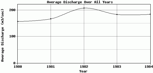
| 1980 | 170 | 241 | 173 | 132 | 45.5 | 59 | 66.5 | 109 | 196 | 184 | 236 | 275 | 157.25 |
| 1981 | 299 | 208 | 274 | 100 | 72.5 | 86.5 | 59 | 48 | 184 | 237 | 290 | 149 | 167.25 |
| 1982 | 247 | 246 | 297 | 140 | 95.5 | 50.5 | 37 | 77 | 208 | 390 | 391 | 316 | 207.92 |
| 1983 | 471 | 172 | 236 | 137 | 231 | 126 | 43.5 | 29 | 94 | 299 | 114 | 254 | 183.88 |
| 1984 | 316 | 269 | 234 | 209 | 71.5 | 52 | 31.5 | 25 | 68.5 | 186 | 408 | 342 | 184.38 |
| |
|
|
|
|
|
|
|
|
|
|
|
|
|
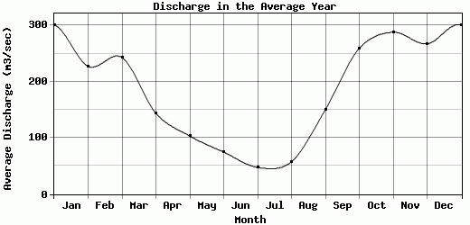
| Avg | 300.6 | 227.2 | 242.8 | 143.6 | 103.2 | 74.8 | 47.5 | 57.6 | 150.1 | 259.2 | 287.8 | 267.2 | 180.14 |
| |
|
|
|
|
|
|
|
|
|
|
|
|
|
| Std Dev | 99.2 |
33.78 |
42.21 |
35.69 |
65.83 |
28.7 |
13.23 |
31.59 |
57.3 |
77.72 |
107.7 |
66.61 |
17.28 |
| |
|
|
|
|
|
|
|
|
|
|
|
|
|
| | Jan | Feb | Mar | Apr | May | Jun | Jul | Aug | Sep | Oct | Nov | Dec | Avg Annual |
Click here for this table in tab-delimited format.
Tab-delimited format will open in most table browsing software, i.e. Excel, etc.
View this station on the map.
Return to start.