Results
| Country: | Iceland
| | Station: | Urridafoss | | River: | Thjorsa | | Area: | 7200 km2 | | Lat: | 63.93 | | Lon: | -20.64 | | Source: | RivDIS | | PointID: | 188 | | Area Units: | km2 | | Discharge Units: | m3/sec | | Starting Year: | 1965 | | Ending Year: | 1979 | | Total Years: | 15 | | Total Usable Years: | 14 | |
| |
| Year | Jan | Feb | Mar | Apr | May | Jun | Jul | Aug | Sep | Oct | Nov | Dec | Avg Annual |
|---|
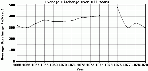
| 1965 | 211 | 371 | 187 | 261 | 408 | 336 | 455 | 431 | 247 | 456 | 262 | 182 | 317.25 |
| 1966 | 193 | 133 | 179 | 189 | 445 | 630 | 457 | 427 | 294 | 205 | 258 | 168 | 298.17 |
| 1967 | 295 | 223 | 158 | 298 | 363 | 852 | 394 | 369 | 369 | 204 | 209 | 290 | 335.33 |
| 1968 | 198 | 263 | 315 | 334 | 406 | 793 | 431 | 506 | 434 | 199 | 318 | 215 | 367.67 |
| 1969 | 235 | 190 | 282 | 330 | 518 | 579 | 407 | 570 | 390 | 320 | 211 | 238 | 355.83 |
| 1970 | 291 | 228 | 215 | 223 | 560 | 717 | 392 | 451 | 337 | 355 | 195 | 328 | 357.67 |
| 1971 | 179 | 296 | 282 | 286 | 663 | 516 | 429 | 404 | 423 | 324 | 289 | 269 | 363.33 |
| 1972 | 352 | 290 | 324 | 276 | 782 | 440 | 492 | 424 | 368 | 332 | 276 | 308 | 388.67 |
| 1973 | 442 | 312 | 376 | 433 | 484 | 549 | 443 | 373 | 349 | 370 | 341 | 291 | 396.92 |
| 1974 | 275 | 328 | 367 | 785 | 592 | 523 | 434 | 413 | 314 | 278 | 276 | 298 | 406.92 |
| 1975 | -9999 | -9999 | -9999 | -9999 | -9999 | -9999 | -9999 | -9999 | -9999 | -9999 | -9999 | -9999 | -9999 |
| 1976 | 308 | 382 | 334 | 327 | 557 | 914 | 644 | 852 | 478 | 337 | 299 | 296 | 477.33 |
| 1977 | 322 | 300 | 281 | 241 | 447 | 342 | 424 | 377 | 233 | 215 | 239 | 248 | 305.75 |
| 1978 | 296 | 247 | 234 | 241 | 508 | 468 | 413 | 435 | 462 | 233 | 262 | 289 | 340.67 |
| 1979 | 262 | 280 | 254 | 263 | 245 | 637 | 367 | 330 | 234 | 231 | 234 | 246 | 298.58 |
| |
|
|
|
|
|
|
|
|
|
|
|
|
|
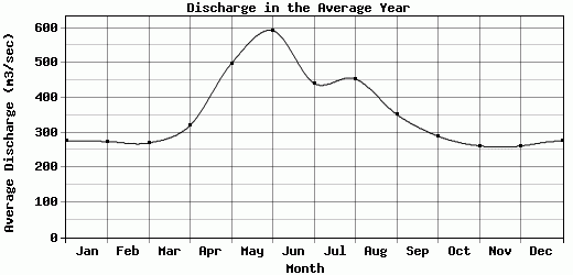
| Avg | 275.64 | 274.5 | 270.57 | 320.5 | 498.43 | 592.57 | 441.57 | 454.43 | 352.29 | 289.93 | 262.07 | 261.86 | 357.86 |
| |
|
|
|
|
|
|
|
|
|
|
|
|
|
| Std Dev | 68.63 |
65.13 |
66.75 |
141.09 |
127.88 |
171.1 |
63.73 |
124.32 |
78.32 |
75.41 |
40.62 |
46.14 |
47.46 |
| |
|
|
|
|
|
|
|
|
|
|
|
|
|
| | Jan | Feb | Mar | Apr | May | Jun | Jul | Aug | Sep | Oct | Nov | Dec | Avg Annual |
Click here for this table in tab-delimited format.
Tab-delimited format will open in most table browsing software, i.e. Excel, etc.
View this station on the map.
Return to start.