Results
| Country: | U.S.A.
| | Station: | DEMOPOLIS L&D NEAR COATOPA, AL. | | River: | TOMBIGBEE R | | Area: | 39844.79 | | Lat: | 32.52 | | Lon: | -87.87 | | Source: | USGS | | PointID: | 2467000 | | Area Units: | km2 | | Discharge Units: | m3/sec | | Starting Year: | 1929 | | Ending Year: | 1934 | | Total Years: | 6 | | Total Usable Years: | 5 | |
| |
| Year | Jan | Feb | Mar | Apr | May | Jun | Jul | Aug | Sep | Oct | Nov | Dec | Avg Annual |
|---|
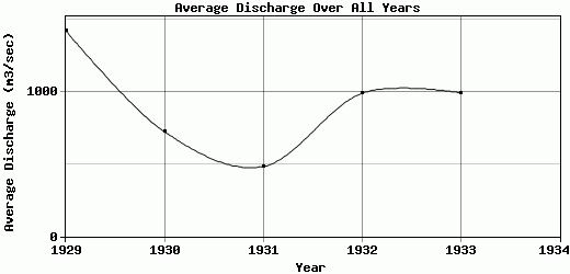
| 1929 | 602.06 | 1208.33 | 5630.52 | 1598.87 | 1970.13 | 652.23 | 526.33 | 401.83 | 370.91 | 423.59 | 2500.49 | 1216.63 | 1425.16 |
| 1930 | 970.82 | 1465.1 | 1676.27 | 843.47 | 571.64 | 337 | 324.74 | 364.15 | 431.99 | 396.71 | 832.9 | 477.64 | 724.37 |
| 1931 | 709.75 | 619.74 | 674.86 | 931.35 | 509.34 | 332.29 | 259.48 | 279.43 | 225.8 | 203.12 | 181.55 | 871.38 | 483.17 |
| 1932 | 1416.03 | 2249.83 | 970.27 | 1081.33 | 772.23 | 466.85 | 667.28 | 457.82 | 397.2 | 464.19 | 611.08 | 2324.19 | 989.86 |
| 1933 | 2814.34 | 2013.95 | 2102.31 | 1670.99 | 712.58 | 427.49 | 472.53 | 365.38 | 358.4 | 337.28 | 329.14 | 329.24 | 994.47 |
| 1934 | -9999 | -9999 | -9999 | -9999 | -9999 | -9999 | -9999 | -9999 | -9999 | -9999 | -9999 | -9999 | -9999 |
| |
|
|
|
|
|
|
|
|
|
|
|
|
|
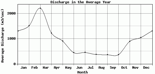
| Avg | 1302.6 | 1511.39 | 2210.85 | 1225.2 | 907.18 | 443.17 | 450.07 | 373.72 | 356.86 | 364.98 | 891.03 | 1043.82 | 923.41 |
| |
|
|
|
|
|
|
|
|
|
|
|
|
|
| Std Dev | 806.29 |
580.84 |
1782.69 |
343.84 |
539.78 |
116.69 |
145.28 |
58.16 |
70.21 |
90.83 |
835.61 |
711.36 |
314.53 |
| |
|
|
|
|
|
|
|
|
|
|
|
|
|
| | Jan | Feb | Mar | Apr | May | Jun | Jul | Aug | Sep | Oct | Nov | Dec | Avg Annual |
Click here for this table in tab-delimited format.
Tab-delimited format will open in most table browsing software, i.e. Excel, etc.
View this station on the map.
Return to start.