Results
| Country: | U.S.A.
| | Station: | EPES, AL. | | River: | TOMBIGBEE RIVER | | Area: | 23127.33 | | Lat: | 32.69 | | Lon: | -88.11 | | Source: | USGS | | PointID: | 2449500 | | Area Units: | km2 | | Discharge Units: | m3/sec | | Starting Year: | 1926 | | Ending Year: | 1928 | | Total Years: | 3 | | Total Usable Years: | 2 | |
| |
| Year | Jan | Feb | Mar | Apr | May | Jun | Jul | Aug | Sep | Oct | Nov | Dec | Avg Annual |
|---|
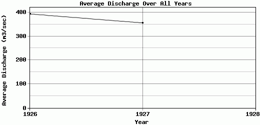
| 1926 | 975.93 | 565.73 | 618.13 | 489.33 | 182.54 | 123.07 | 129.34 | 403.75 | 138.64 | 92 | 269.71 | 737.15 | 393.78 |
| 1927 | 479.74 | 931.1 | 787.21 | 511.64 | 213.72 | 230.14 | 210.97 | 146.37 | 85.04 | 73.49 | 106.92 | 497.36 | 356.14 |
| 1928 | -9999 | -9999 | -9999 | -9999 | -9999 | -9999 | -9999 | -9999 | -9999 | -9999 | -9999 | -9999 | -9999 |
| |
|
|
|
|
|
|
|
|
|
|
|
|
|
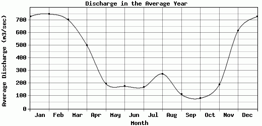
| Avg | 727.84 | 748.42 | 702.67 | 500.49 | 198.13 | 176.61 | 170.16 | 275.06 | 111.84 | 82.75 | 188.32 | 617.26 | 374.96 |
| |
|
|
|
|
|
|
|
|
|
|
|
|
|
| Std Dev | 248.1 |
182.69 |
84.54 |
11.16 |
15.59 |
53.54 |
40.82 |
128.69 |
26.8 |
9.26 |
81.4 |
119.9 |
18.82 |
| |
|
|
|
|
|
|
|
|
|
|
|
|
|
| | Jan | Feb | Mar | Apr | May | Jun | Jul | Aug | Sep | Oct | Nov | Dec | Avg Annual |
Click here for this table in tab-delimited format.
Tab-delimited format will open in most table browsing software, i.e. Excel, etc.
View this station on the map.
Return to start.