Results
| Country: | United_Kingdom
| | Station: | Norham | | River: | Tweed | | Area: | 4390 km2 | | Lat: | 55.71 | | Lon: | -2.16 | | Source: | RivDIS | | PointID: | 1373 | | Area Units: | km2 | | Discharge Units: | m3/sec | | Starting Year: | 1980 | | Ending Year: | 1984 | | Total Years: | 5 | | Total Usable Years: | 5 | |
| |
| Year | Jan | Feb | Mar | Apr | May | Jun | Jul | Aug | Sep | Oct | Nov | Dec | Avg Annual |
|---|
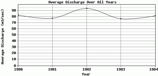
| 1980 | 87 | 133 | 120 | 57 | 18 | 42 | 30 | 60.5 | 54 | 117 | 133 | 142 | 82.79 |
| 1981 | 93 | 60.5 | 155 | 50.5 | 41 | 66 | 43.5 | 18.5 | 57.5 | 159 | 103 | 81.5 | 77.42 |
| 1982 | 250 | 122 | 116 | 28.5 | 26.5 | 31.5 | 36 | 17 | 38 | 118 | 182 | 157 | 93.54 |
| 1983 | 132 | 84.5 | 100 | 96.5 | 148 | 65.5 | 21 | 15.5 | 25.5 | 104 | 25.5 | 102 | 76.67 |
| 1984 | 144 | 173 | 109 | 55.5 | 20 | 23 | 11.5 | 14 | 16.5 | 46.5 | 254 | 109 | 81.33 |
| |
|
|
|
|
|
|
|
|
|
|
|
|
|
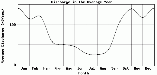
| Avg | 141.2 | 114.6 | 120 | 57.6 | 50.7 | 45.6 | 28.4 | 25.1 | 38.3 | 108.9 | 139.5 | 118.3 | 82.35 |
| |
|
|
|
|
|
|
|
|
|
|
|
|
|
| Std Dev | 58.64 |
39.08 |
18.77 |
21.98 |
49.31 |
17.52 |
11.21 |
17.76 |
15.84 |
36.27 |
76.53 |
27.44 |
6.05 |
| |
|
|
|
|
|
|
|
|
|
|
|
|
|
| | Jan | Feb | Mar | Apr | May | Jun | Jul | Aug | Sep | Oct | Nov | Dec | Avg Annual |
Click here for this table in tab-delimited format.
Tab-delimited format will open in most table browsing software, i.e. Excel, etc.
View this station on the map.
Return to start.