Results
| Country: | New_Zealand
| | Station: | Ngaruawahia | | River: | Waikato | | Area: | 11395 km2 | | Lat: | -37.68 | | Lon: | 175.15 | | Source: | RivDIS | | PointID: | 1382 | | Area Units: | km2 | | Discharge Units: | m3/sec | | Starting Year: | 1976 | | Ending Year: | 1984 | | Total Years: | 9 | | Total Usable Years: | 8 | |
| |
| Year | Jan | Feb | Mar | Apr | May | Jun | Jul | Aug | Sep | Oct | Nov | Dec | Avg Annual |
|---|
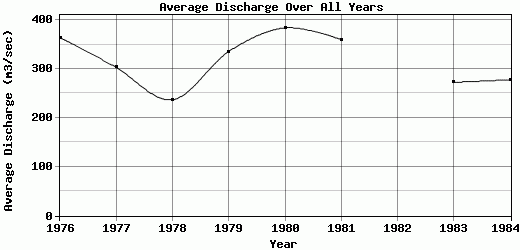
| 1976 | 309 | 330 | 255 | 239 | 305 | 371 | 557 | 565 | 477 | 430 | 312 | 218 | 364 |
| 1977 | 199 | 165 | 193 | 190 | 312 | 416 | 513 | 449 | 409 | 342 | 225 | 225 | 303.17 |
| 1978 | 203 | 204 | 167 | 157 | 171 | 215 | 381 | 292 | 274 | 256 | 309 | 216 | 237.08 |
| 1979 | 182 | 223 | 255 | 273 | 401 | 333 | 404 | 432 | 350 | 461 | 391 | 319 | 335.33 |
| 1980 | 433 | 349 | 318 | 321 | 303 | 373 | 476 | 446 | 464 | 367 | 357 | 401 | 384 |
| 1981 | 311 | 267 | 262 | 298 | 282 | 451 | 482 | 502 | 425 | 391 | 349 | 299 | 359.92 |
| 1982 | 275 | 254 | 239 | 236 | 293 | 309 | 304 | 274 | -9999 | 277 | 240 | 207 | -9999 |
| 1983 | 220 | 198 | 165 | 194 | 263 | 298 | 293 | 253 | 299 | 392 | 416 | 280 | 272.58 |
| 1984 | 254 | 224 | 262 | 238 | 237 | 312 | 353 | 358 | 305 | 277 | 240 | 273 | 277.75 |
| |
|
|
|
|
|
|
|
|
|
|
|
|
|
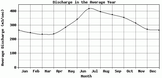
| Avg | 265.11 | 246 | 235.11 | 238.44 | 285.22 | 342 | 418.11 | 396.78 | 375.38 | 354.78 | 315.44 | 270.89 | 316.73 |
| |
|
|
|
|
|
|
|
|
|
|
|
|
|
| Std Dev | 74.25 |
57.55 |
47.67 |
50.02 |
58.47 |
66.08 |
88.33 |
102.19 |
73.72 |
68.16 |
65.23 |
59.74 |
48.69 |
| |
|
|
|
|
|
|
|
|
|
|
|
|
|
| | Jan | Feb | Mar | Apr | May | Jun | Jul | Aug | Sep | Oct | Nov | Dec | Avg Annual |
Click here for this table in tab-delimited format.
Tab-delimited format will open in most table browsing software, i.e. Excel, etc.
View this station on the map.
Return to start.