Results
| Country: | U.S.A.
| | Station: | KALTAG AK | | River: | YUKON R | | Area: | 766594.56 | | Lat: | 64.32 | | Lon: | -158.72 | | Source: | USGS | | PointID: | 15565200 | | Area Units: | km2 | | Discharge Units: | m3/sec | | Starting Year: | 1982 | | Ending Year: | 1986 | | Total Years: | 5 | | Total Usable Years: | 4 | |
| |
| Year | Jan | Feb | Mar | Apr | May | Jun | Jul | Aug | Sep | Oct | Nov | Dec | Avg Annual |
|---|
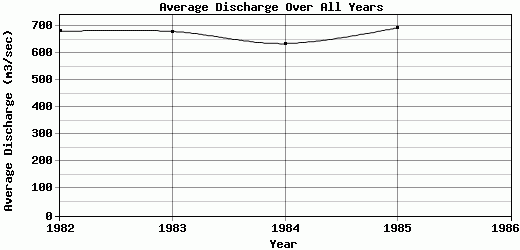
| 1982 | 99.11 | 91.42 | 81.48 | 107.7 | 752.14 | 1778.97 | 1784.79 | 1290.89 | 1382.72 | 458.17 | 178.4 | 158.94 | 680.39 |
| 1983 | 147.71 | 132.08 | 98.56 | 118.84 | 888.79 | 1645.12 | 1568.12 | 1715.46 | 849.89 | 604.16 | 234.28 | 157.3 | 680.03 |
| 1984 | 138.66 | 130.26 | 127.34 | 128.94 | 734.01 | 1678.54 | 1674.63 | 1662.85 | 678.1 | 349.76 | 177.08 | 138.11 | 634.86 |
| 1985 | 129.25 | 108.21 | 106.14 | 115.72 | 729.21 | 1723.56 | 1926.56 | 1558.26 | 1154.11 | 472.35 | 172.07 | 121.95 | 693.12 |
| 1986 | -9999 | -9999 | -9999 | -9999 | -9999 | -9999 | -9999 | -9999 | -9999 | -9999 | -9999 | -9999 | -9999 |
| |
|
|
|
|
|
|
|
|
|
|
|
|
|
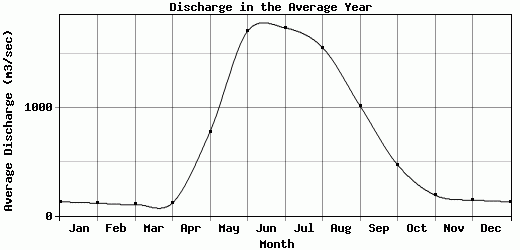
| Avg | 128.68 | 115.49 | 103.38 | 117.8 | 776.04 | 1706.55 | 1738.53 | 1556.87 | 1016.21 | 471.11 | 190.46 | 144.08 | 672.1 |
| |
|
|
|
|
|
|
|
|
|
|
|
|
|
| Std Dev | 18.28 |
16.78 |
16.47 |
7.61 |
65.66 |
50.23 |
132.87 |
163.65 |
271.72 |
90.27 |
25.41 |
15.17 |
22.14 |
| |
|
|
|
|
|
|
|
|
|
|
|
|
|
| | Jan | Feb | Mar | Apr | May | Jun | Jul | Aug | Sep | Oct | Nov | Dec | Avg Annual |
Click here for this table in tab-delimited format.
Tab-delimited format will open in most table browsing software, i.e. Excel, etc.
View this station on the map.
Return to start.